
IMAGES TAKEN NEAR TO
Church Street, PWLLHELI, LL53 5SH
Introduction
This page details the photographs taken nearby to Church Street, LL53 5SH by members of the Geograph project.
The Geograph project started in 2005 with the aim of publishing, organising and preserving representative images for every square kilometre of Great Britain, Ireland and the Isle of Man.

There are currently over 7.5m images from over14,400 individuals and you can help contribute to the project by visiting https://www.geograph.org.uk
Image Map
Images are licensed for reuse under creativecommons.org/licenses/by-sa/2.0
Notes
- Clicking on the map will re-center to the selected point.
- The higher the marker number, the further away the image location is from the centre of the postcode.
Image Listing (505 Images Found)
Images are licensed for reuse under creativecommons.org/licenses/by-sa/2.0
Image
Details
Distance
2

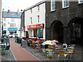
Marwolaeth Tref? - The Death of a Town?
Even the charity shops are affected. Tenovus, the cancer charity, opened this short-lived cafe.
For comments see Image
Image: © Alan Fryer
Taken: 30 Dec 2007
0.01 miles
3

The Original Factory Shop
Pwllheli's Woolworths store reopened not long after the closure as a branch of The Original Factory Shop, as did the stores in Porthmadog and Barmouth.
Image: © Alan Fryer
Taken: 4 Nov 2012
0.02 miles
4
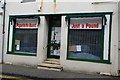
Marwolaeth Tref? - The Death of a Town?
The discount shop has also closed down due to falling business.
For comments see Image
Image: © Alan Fryer
Taken: 30 Dec 2007
0.02 miles
6
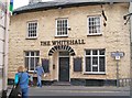
The Whitehall Hotel, Gaol Street, Pwllheli
The writing on the door states, in Welsh, "Opening, Today 5"
http://the-whitehall-hotel.wales.info/
Image: © Eric Jones
Taken: 17 Jun 2010
0.02 miles
7
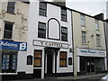
Y Castell
The pub has recently been relet and renovated.
Image: © Alan Fryer
Taken: 20 Nov 2011
0.03 miles
8
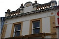
Siop Caerhydderch Pwllheli
Just visible above the upper windows of this shop on Stryd Fawr is the outline of the name Caerhydderch. Cae Rhydderch is a farm in Rhoshirwaun. In years gone by a number of farmers on the peninsula owned shops in Pwllheli, the eldest son of the family inheriting the farm and the second son becoming a shopkeeper.
Image: © Alan Fryer
Taken: 30 Dec 2007
0.03 miles
9
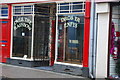
Marwolaeth Tref? - The Death of a Town?
A recent closure on Stryd Fawr.
For comments see Image
Image: © Alan Fryer
Taken: 30 Dec 2007
0.03 miles
10
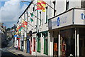
Pwllheli'n dathlu ei Chymreictod - Pwllheli celebrates its Welshness
Stryd Fawr Pwllheli flying all the flags of the nation - Y Ddraig Goch (red, green and white), Baner Owain Glyndŵr (red and gold) and Baner Dewi Sant (black and gold)
Image: © Alan Fryer
Taken: 17 Jul 2007
0.03 miles