IMAGES TAKEN NEAR TO
Ffordd Y Maer, PWLLHELI, LL53 5ES
Introduction
This page details the photographs taken nearby to Ffordd Y Maer, LL53 5ES by members of the Geograph project.
The Geograph project started in 2005 with the aim of publishing, organising and preserving representative images for every square kilometre of Great Britain, Ireland and the Isle of Man.

There are currently over 7.5m images from over14,400 individuals and you can help contribute to the project by visiting https://www.geograph.org.uk
Image Map
Images are licensed for reuse under creativecommons.org/licenses/by-sa/2.0
Notes
- Clicking on the map will re-center to the selected point.
- The higher the marker number, the further away the image location is from the centre of the postcode.
Image Listing (303 Images Found)
Images are licensed for reuse under creativecommons.org/licenses/by-sa/2.0
Image
Details
Distance
1
Pwllheli : Ffordd-Y-Maer
Looking along Ffordd-Y-Maer.
Image: © Lewis Clarke
Taken: 20 Apr 2024
0.01 miles
3
Pwllheli : Footpath
A footpath off Ffordd-Y-Maer to the park.
Image: © Lewis Clarke
Taken: 20 Apr 2024
0.03 miles
4
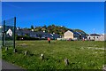
Pwllheli : Play Area
A field and playground.
Image: © Lewis Clarke
Taken: 20 Apr 2024
0.03 miles
5
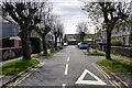
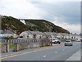
Pwllheli : Ffordd-Y-Maer
Looking off the A497.
Image: © Lewis Clarke
Taken: 19 Apr 2024
0.03 miles
6
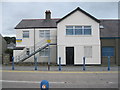
Hen Neuadd Ymarfer Pwllheli - Former Pwllheli Drillhall
Currently used as a council store
Image: © Alan Fryer
Taken: 5 Aug 2014
0.03 miles
7
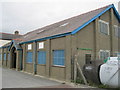
Hen Neuadd Ymarfer Pwllheli - Former Pwllheli Drillhall
Image: © Alan Fryer
Taken: 5 Aug 2014
0.03 miles
8
North Quay Pwllheli
This is an area of land reclaimed at the beginning of the 20th century.
Image: © John Lucas
Taken: 30 Oct 2008
0.05 miles
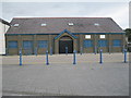
9
ACF Clwyd a Gwynedd
Army Cadet Force building
The building to the right is Image
Image: © Alan Fryer
Taken: 5 Aug 2014
0.05 miles