IMAGES TAKEN NEAR TO
Penlan Street, PWLLHELI, LL53 5DE
Introduction
This page details the photographs taken nearby to Penlan Street, LL53 5DE by members of the Geograph project.
The Geograph project started in 2005 with the aim of publishing, organising and preserving representative images for every square kilometre of Great Britain, Ireland and the Isle of Man.

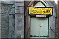
There are currently over 7.5m images from over14,400 individuals and you can help contribute to the project by visiting https://www.geograph.org.uk
Image Map (Loading...)


Getting Data...Please wait
Leaflet Map data © OpenStreetMap
Images are licensed for reuse under creativecommons.org/licenses/by-sa/2.0
Notes
- Clicking on the map will re-center to the selected point.
- The higher the marker number, the further away the image location is from the centre of the postcode.
Image Listing (527 Images Found)
Images are licensed for reuse under creativecommons.org/licenses/by-sa/2.0
Image
Details
Distance
1
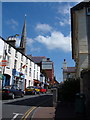
Stryd Penlan, Pwllheli
The red brick building on the left is the theatre and cinema. On the opposite side of the road, the white building is the oldest pub, the Penlan Fawr, dating from the early seventeenth century. More photos of the area can be found on http://www.pwllheli.org.uk/photos.html
Image: © Alison Pryce
Taken: 10 Jul 2005
0.00 miles
2
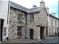
The Penlan Fawr Inn in Penlan Street, Pwllheli
Image: © Eric Jones
Taken: 5 Aug 2010
0.00 miles
3
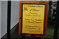
Ysgol Dawns Pwllheli School of Dance
Housed in part of Image
Image: © Alan Fryer
Taken: 30 Dec 2007
0.00 miles
4
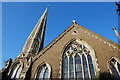
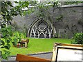
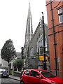
Y Tabernacl
Officially named Y Tabernacl, but known locally as Capal Batus (Baptist Chapel). Built in 1861, the building is unusual for having a spire - one of very few in the area. The spire was used by local fishermen for getting their bearings when setting their nets. The building is no longer used as a chapel and is privately owned.
Image: © Alan Fryer
Taken: 18 Dec 2007
0.01 miles
5
Y Tabernacl
The door of Image showing its present use.
Image: © Alan Fryer
Taken: 18 Dec 2007
0.01 miles
6
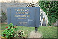
Y Tabernacl
The nameboard of the former chapel (Image) has been preserved, but the name of the Minister and Next Sunday's Preacher will remain forever blank.
Image: © Alan Fryer
Taken: 18 Dec 2007
0.01 miles
7
Low window on Y Tabernacl
This former Baptist Chapel is now an emporium selling old maps. This ground level window attracted my eye.
For a wider view see http://www.geograph.org.uk/photo/3091184 and for more of its history see http://www.geograph.org.uk/photo/635752.
Image: © Penny Mayes
Taken: 18 Jul 2012
0.01 miles
8
Y Tabernacl
This former Baptist Chapel is now an emporium selling old maps.
For a view of its unusual ground-level window see http://www.geograph.org.uk/photo/3088629.
For more of its history see http://www.geograph.org.uk/photo/635752.
Apologies for the barrel distortion which makes it look as if the red brick building, Neuadd Dwyfor, on the right is falling over.
Image: © Penny Mayes
Taken: 18 Jul 2012
0.01 miles
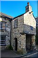
9
Penlan Fawr
The damage shown in Image has now been repaired.
Image: © Alan Fryer
Taken: 19 Jun 2012
0.01 miles
10
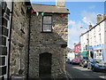
Pwllheli : Building
A building Stryd Penlan.
Image: © Lewis Clarke
Taken: 19 Apr 2024
0.01 miles