IMAGES TAKEN NEAR TO
Ala Road, PWLLHELI, LL53 5BW
Introduction
This page details the photographs taken nearby to Ala Road, LL53 5BW by members of the Geograph project.
The Geograph project started in 2005 with the aim of publishing, organising and preserving representative images for every square kilometre of Great Britain, Ireland and the Isle of Man.

There are currently over 7.5m images from over14,400 individuals and you can help contribute to the project by visiting https://www.geograph.org.uk
Image Map (Loading...)


Getting Data...Please wait
Leaflet Map data © OpenStreetMap
Images are licensed for reuse under creativecommons.org/licenses/by-sa/2.0
Notes
- Clicking on the map will re-center to the selected point.
- The higher the marker number, the further away the image location is from the centre of the postcode.
Image Listing (19 Images Found)
Images are licensed for reuse under creativecommons.org/licenses/by-sa/2.0
Image
Details
Distance
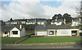
1
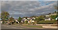
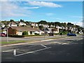
The Ala Estate from the east
This view is taken from Yr Ala road.
Image: © Eric Jones
Taken: 25 Sep 2010
0.02 miles
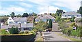
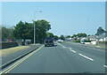
4
Bungalows and houses on Yr Ala Estate, Pwllheli
This estate runs parallel with the A499.
Image: © Eric Jones
Taken: 25 Jun 2010
0.06 miles
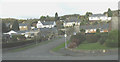
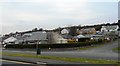
9
New bungalows on the western approach to the town
Image: © Eric Jones
Taken: 9 Nov 2007
0.08 miles
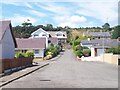
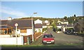
10

Victorian houses on Yr Ala
These when built were on the fringe of the town, now estates of bungalows separate them from the open countryside.
Image: © Eric Jones
Taken: 31 Jul 2010
0.11 miles