IMAGES TAKEN NEAR TO
Manor Avenue, PWLLHELI, LL53 5AF
Introduction
This page details the photographs taken nearby to Manor Avenue, LL53 5AF by members of the Geograph project.
The Geograph project started in 2005 with the aim of publishing, organising and preserving representative images for every square kilometre of Great Britain, Ireland and the Isle of Man.

There are currently over 7.5m images from over14,400 individuals and you can help contribute to the project by visiting https://www.geograph.org.uk
Image Map (Loading...)


Getting Data...Please wait
Leaflet Map data © OpenStreetMap
Images are licensed for reuse under creativecommons.org/licenses/by-sa/2.0
Notes
- Clicking on the map will re-center to the selected point.
- The higher the marker number, the further away the image location is from the centre of the postcode.
Image Listing (68 Images Found)
Images are licensed for reuse under creativecommons.org/licenses/by-sa/2.0
Image
Details
Distance
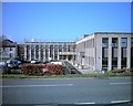
1
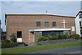
Eglwys Gatholig St Joseph - St Joseph's Catholic Church
Image: © Alan Fryer
Taken: 4 Oct 2015
0.03 miles
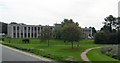
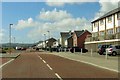
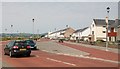
2
Embankment Road
Looking along Embankment Road from a path leading to Bron-y-de.
Image: © DS Pugh
Taken: 3 Aug 2018
0.08 miles
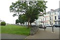
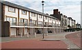
5
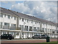
Min y M?r
Town houses on the promenade at Pwllheli
Image: © Alan Fryer
Taken: 15 Jul 2012
0.09 miles
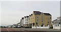
8
Modern developments along the Prom at Pwllheli
Until recently much of the South Beach was undeveloped land.
Image: © Eric Jones
Taken: 17 Jun 2010
0.10 miles
9
Modern and Victorian apartments on the Promenade
Image: © Eric Jones
Taken: 17 Jun 2010
0.10 miles