IMAGES TAKEN NEAR TO
Rhoslan, CRICCIETH, LL52 0NW
Introduction
This page details the photographs taken nearby to LL52 0NW by members of the Geograph project.
The Geograph project started in 2005 with the aim of publishing, organising and preserving representative images for every square kilometre of Great Britain, Ireland and the Isle of Man.

There are currently over 7.5m images from over14,400 individuals and you can help contribute to the project by visiting https://www.geograph.org.uk
Image Map (Loading...)


Getting Data...Please wait
Leaflet Map data © OpenStreetMap
Images are licensed for reuse under creativecommons.org/licenses/by-sa/2.0
Notes
- Clicking on the map will re-center to the selected point.
- The higher the marker number, the further away the image location is from the centre of the postcode.
Image Listing (11 Images Found)
Images are licensed for reuse under creativecommons.org/licenses/by-sa/2.0
Image
Details
Distance
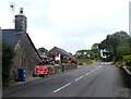
2
Capel Rhoslan
A typical chapel of the Welsh countryside.
Image: © Dewi
Taken: Unknown
0.09 miles
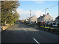
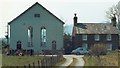
4
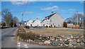
Maes Eifion Estate, Rhoslan
These local authority built houses stand alongside the busy B4411.
Image: © Eric Jones
Taken: 9 Mar 2010
0.19 miles