IMAGES TAKEN NEAR TO
Llanystumdwy, CRICCIETH, LL52 0LT
Introduction
This page details the photographs taken nearby to LL52 0LT by members of the Geograph project.
The Geograph project started in 2005 with the aim of publishing, organising and preserving representative images for every square kilometre of Great Britain, Ireland and the Isle of Man.

There are currently over 7.5m images from over14,400 individuals and you can help contribute to the project by visiting https://www.geograph.org.uk
Image Map (Loading...)


Getting Data...Please wait
Leaflet Map data © OpenStreetMap
Images are licensed for reuse under creativecommons.org/licenses/by-sa/2.0
Notes
- Clicking on the map will re-center to the selected point.
- The higher the marker number, the further away the image location is from the centre of the postcode.
Image Listing (6 Images Found)
Images are licensed for reuse under creativecommons.org/licenses/by-sa/2.0
Image
Details
Distance
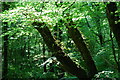
1
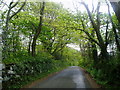
Country lane
An old country lane with dry stone walls overgrown over the years and trees forming an archway over the road.
Image: © Eirian Evans
Taken: 9 May 2005
0.19 miles
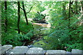
3
Bridge over Afon Dwyfach
Carries a single track minor road.
Image: © Robin Drayton
Taken: 31 Oct 2014
0.24 miles
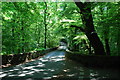
4
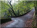
Junction of minor roads
The road to the left crosses Afon Dwyfach http://www.geograph.org.uk/photo/4237932 .
Image: © Robin Drayton
Taken: 31 Oct 2014
0.24 miles
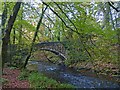
6
Yr Hen Bont
The bridge (Pont Rhyd-y-croesau) crosses Afon Dwyfach on the road from Llanystumdwy to Llangybi. The nearby Plas Talhenbont (Hall at the end of the old bridge) stands nearby on the west bank of the Dwyfach.
The two rivers of Llanystumdwy, Dwyfor and Dwyfach, have since ancient times been considered holy, and their names are based on the old Welsh dwy (god or divinity), with the epithets bach (small) and mawr (large).
Image: © Alan Fryer
Taken: 15 May 2008
0.24 miles