IMAGES TAKEN NEAR TO
Bryntirion Terrace, CRICCIETH, LL52 0AT
Introduction
This page details the photographs taken nearby to Bryntirion Terrace, LL52 0AT by members of the Geograph project.
The Geograph project started in 2005 with the aim of publishing, organising and preserving representative images for every square kilometre of Great Britain, Ireland and the Isle of Man.

There are currently over 7.5m images from over14,400 individuals and you can help contribute to the project by visiting https://www.geograph.org.uk
Image Map (Loading...)


Getting Data...Please wait
Leaflet Map data © OpenStreetMap
Images are licensed for reuse under creativecommons.org/licenses/by-sa/2.0
Notes
- Clicking on the map will re-center to the selected point.
- The higher the marker number, the further away the image location is from the centre of the postcode.
Image Listing (135 Images Found)
Images are licensed for reuse under creativecommons.org/licenses/by-sa/2.0
Image
Details
Distance
1
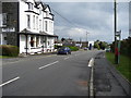
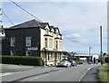
Part of Criccieth town
Coming into Criccieth down the B4411 you pass hotels, car dealerships, guest houses and get distant views down to the castle.
Image: © Jeremy Bolwell
Taken: 13 Jun 2010
0.01 miles
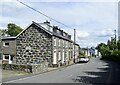
2
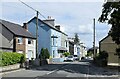
Varied dwellings on the B4411, Criccieth
Image: © Bill Harrison
Taken: 3 Jul 2022
0.03 miles
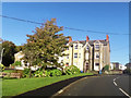
3
Mynydd Ednyfed Country Hotel
In Caernarfon Road Criccieth
Image: © John Firth
Taken: 8 Oct 2010
0.03 miles
4
Cricieth o Lon Fel / Criccieth from Lon Fel
Image: © Ceri Thomas
Taken: 19 Jun 2021
0.04 miles
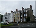
6
Terrace on the B4411, Criccieth
The B4411 climbs steeply out of Criccieth to join the A487 after about 7 km: https://www.sabre-roads.org.uk/wiki/index.php?title=B4411 .
Image: © Bill Harrison
Taken: 3 Jul 2022
0.10 miles
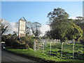
7
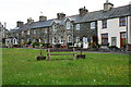
Rhes Ffynnon - Holywell Terrace
This terrace of houses stands at the very northern end of Y Maes on Ffordd Caernarfon.
Image: © Alan Fryer
Taken: 23 May 2008
0.12 miles
10
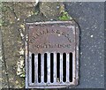
Drain cover made by Williams of Porthmadog
There seem to have been several ironworks in Porthmadog mostly serving the slate mines: https://www.irsociety.co.uk/Archives/49/Britannia.htm . Note the obsolete spelling of 'Portmadoc'.
Image: © Bill Harrison
Taken: 10 Jul 2023
0.12 miles