IMAGES TAKEN NEAR TO
GARNDOLBENMAEN, LL51 9UX
Introduction
This page details the photographs taken nearby to LL51 9UX by members of the Geograph project.
The Geograph project started in 2005 with the aim of publishing, organising and preserving representative images for every square kilometre of Great Britain, Ireland and the Isle of Man.

There are currently over 7.5m images from over14,400 individuals and you can help contribute to the project by visiting https://www.geograph.org.uk
Image Map
Images are licensed for reuse under creativecommons.org/licenses/by-sa/2.0
Notes
- Clicking on the map will re-center to the selected point.
- The higher the marker number, the further away the image location is from the centre of the postcode.
Image Listing (9 Images Found)
Images are licensed for reuse under creativecommons.org/licenses/by-sa/2.0
Image
Details
Distance
1
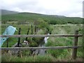
Bridge over a stream north of Garndolbenmaen
Image: © Andrew Longton
Taken: 9 Jul 2006
0.09 miles
2
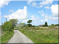
The road to Cefntrefor isaf farm
This no-through road leads up eventually to Fferm Cefntrefor isaf. The house on the corner is Glan-y-don. There are a number of other cottages along the road.
Image: © Eric Jones
Taken: 29 May 2007
0.10 miles
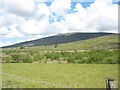
4
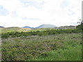
Gors Graianog with Moel Hebog in the background
Image: © Eric Jones
Taken: 29 May 2007
0.13 miles
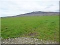
5
View across pasture towards the wooded area of Gors Graianog
Image: © Eric Jones
Taken: 29 May 2007
0.15 miles
6
Gors Graianog a molina bog
The light coloured bogland stands in marked contrast to the surrounding area.
Image: © Eric Jones
Taken: 29 May 2007
0.21 miles
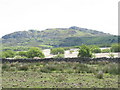
7
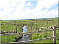
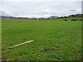
Farmland south of Mynydd Graig Goch
Bordering the Garndolbenmaen - Dafarn Faig road.
Image: © Christine Johnstone
Taken: 29 Apr 2017
0.22 miles
8
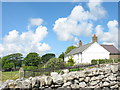
Lon-gert
A friend from the locality has kindly provided some of the history of this interesting house. He writes:
"Lôn Gert goes back to the 1830s, when it appears to have been a typical "two
up, two down" cottage. At some stage a lean-to kitchen was added and a
porch conservatory. In the early 1990s the house was completely gutted and
extended - sadly an ingle nook fireplace was destroyed in the process."
Image: © Eric Jones
Taken: 29 May 2007
0.22 miles
9
Farmland west of Llidiart Mawr
About 160 metres above sea level, and drained by Afon Blaen-y-cae.
Image: © Christine Johnstone
Taken: 29 Apr 2017
0.23 miles