IMAGES TAKEN NEAR TO
GARNDOLBENMAEN, LL51 9RQ
Introduction
This page details the photographs taken nearby to LL51 9RQ by members of the Geograph project.
The Geograph project started in 2005 with the aim of publishing, organising and preserving representative images for every square kilometre of Great Britain, Ireland and the Isle of Man.

There are currently over 7.5m images from over14,400 individuals and you can help contribute to the project by visiting https://www.geograph.org.uk
Image Map (Loading...)


Getting Data...Please wait
Leaflet Map data © OpenStreetMap
Images are licensed for reuse under creativecommons.org/licenses/by-sa/2.0
Notes
- Clicking on the map will re-center to the selected point.
- The higher the marker number, the further away the image location is from the centre of the postcode.
Image Listing (36 Images Found)
Images are licensed for reuse under creativecommons.org/licenses/by-sa/2.0
Image
Details
Distance
1
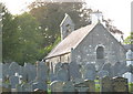
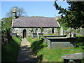
Eglwys Blwyf Dolbenmaen Parish Church
The church is dedicated to the BVM. The parish includes two other churches, St Michael's at Llanfihangel-y-pennant and St Beuno's at Penmorfa.
Image: © Eric Jones
Taken: 10 Oct 2006
0.05 miles
3
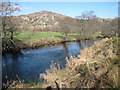
The Afon Dwyfor
With Carreg y Llan in the background.
Image: © David Medcalf
Taken: 1 Mar 2011
0.06 miles
4
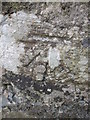
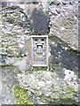
Ordnance Survey 1GL Bolt
This OS Bolt can be found on the west face of St Mary's Church. It marks a point 94.005m above mean sea level.
Image: © Adrian Dust
Taken: 31 Mar 2016
0.07 miles

7
Flush bracket G2625 at Plas Dolbenmaen, Dolbenmaen
This flush bracket is located on the NE face of Plas Dolbenmaen in Dolbenmaen & it is shown in the Ordnance Survey database as being 91.7821m above the Newlyn datum.
Image: © Meirion
Taken: 27 Jan 2011
0.10 miles
8
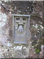
Ordnance Survey Flush Bracket (G2625)
This OS Flush bracket can be found on the NE face of the barn. It marks a point 91.782m above mean sea level.
Image: © Adrian Dust
Taken: 31 Mar 2016
0.10 miles
10
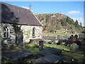
Church and Crag
The crag is Carreg y Llan, translated as Church Crag.
Image: © David Medcalf
Taken: 1 Mar 2011
0.10 miles