IMAGES TAKEN NEAR TO
GARNDOLBENMAEN, LL51 9RJ
Introduction
This page details the photographs taken nearby to LL51 9RJ by members of the Geograph project.
The Geograph project started in 2005 with the aim of publishing, organising and preserving representative images for every square kilometre of Great Britain, Ireland and the Isle of Man.

There are currently over 7.5m images from over14,400 individuals and you can help contribute to the project by visiting https://www.geograph.org.uk
Image Map (Loading...)


Getting Data...Please wait
Leaflet Map data © OpenStreetMap
Images are licensed for reuse under creativecommons.org/licenses/by-sa/2.0
Notes
- Clicking on the map will re-center to the selected point.
- The higher the marker number, the further away the image location is from the centre of the postcode.
Image Listing (23 Images Found)
Images are licensed for reuse under creativecommons.org/licenses/by-sa/2.0
Image
Details
Distance
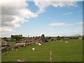

3
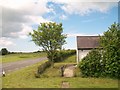
Sheep pasture north of Ty Newydd
East of the road between Dolbenmaen and Garndolbenmaen.
Image: © Christine Johnstone
Taken: 29 Apr 2017
0.13 miles
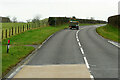
4
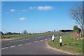
Large lay-by on the road from Garndolbenmaen
Created when a bend was eased.
Image: © Christine Johnstone
Taken: 29 Apr 2017
0.13 miles
5
The A487 at the eastern turnoff for Garndolbenmaen
Image: © Eric Jones
Taken: 16 Apr 2010
0.15 miles
6
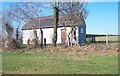
The Dolbenmaen Automatic Telephone Exchange
Image: © Eric Jones
Taken: 16 Apr 2010
0.15 miles
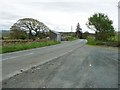
8
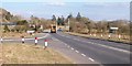
The turnoff for Garndolbenmaen at the entrance to the hamlet of Dolbenmaen
Dolbenmaen means "rock top meadow" and Garndolbenmaen (known locally as just "Garn") means "cairn of the rock top meadow"
Image: © Eric Jones
Taken: 9 Mar 2010
0.15 miles
9

The junction of the Garn road with the A487 at Dolbenmaen
Image: © Eric Jones
Taken: 14 Jan 2008
0.15 miles