IMAGES TAKEN NEAR TO
Prenteg, PORTHMADOG, LL49 9TE
Introduction
This page details the photographs taken nearby to LL49 9TE by members of the Geograph project.
The Geograph project started in 2005 with the aim of publishing, organising and preserving representative images for every square kilometre of Great Britain, Ireland and the Isle of Man.

There are currently over 7.5m images from over14,400 individuals and you can help contribute to the project by visiting https://www.geograph.org.uk
Image Map
Images are licensed for reuse under creativecommons.org/licenses/by-sa/2.0
Notes
- Clicking on the map will re-center to the selected point.
- The higher the marker number, the further away the image location is from the centre of the postcode.
Image Listing (14 Images Found)
Images are licensed for reuse under creativecommons.org/licenses/by-sa/2.0
Image
Details
Distance
1
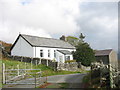
A Converted Chapel and a Cattle Grid
This pretty bungalow with a magnificent view is a former Calvinistic Methodist chapel, Capel Horeb.
Image: © Eric Jones
Taken: 20 Oct 2006
0.04 miles
2
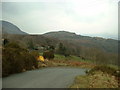
Unclassified road near Prenteg
Looking north across one of the steep hairpins
Image: © David Medcalf
Taken: 24 Feb 2006
0.10 miles
3
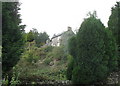
Wayside Cottage
I sighted two very noisy, but camera shy, jays in the garden of this secluded cottage.
Image: © Eric Jones
Taken: 20 Oct 2006
0.10 miles
4
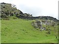
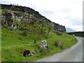
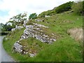
Drystone wall climbing a hillside
East of Ty Mawr, on the north side of the minor road.
Image: © Christine Johnstone
Taken: 30 May 2015
0.12 miles
5
Drystone wall on a steep hillside near Ty Mawr
The ingenuity and skill of the builders!
Image: © Christine Johnstone
Taken: 30 May 2015
0.12 miles
6
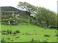
Field boundary, east of Ty Mawr
The trees have been swept back by the prevailing wind rushing up the hillside from the coast. The drystone wall climbs through the exposed rock.
Image: © Christine Johnstone
Taken: 30 May 2015
0.14 miles
7
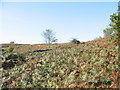
Bracken Infestation above Coed Aber-dunant Wood
Image: © Eric Jones
Taken: 14 Oct 2006
0.15 miles
8
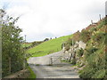
Cattle Grid denoting the boundary between Fferm Hendre Hywel and Ty Mawr
Image: © Eric Jones
Taken: 20 Oct 2006
0.15 miles
9
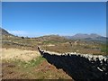
Stone wall scenery
With the Moelwyns and Cnicht in the distance.
Image: © David Medcalf
Taken: 19 Apr 2020
0.15 miles
10
Exposed rock alongside the road to Llyn Du
On the north side of the road, just east of Ty Mawr.
Image: © Christine Johnstone
Taken: 30 May 2015
0.16 miles