IMAGES TAKEN NEAR TO
Penmorfa, PORTHMADOG, LL49 9RT
Introduction
This page details the photographs taken nearby to LL49 9RT by members of the Geograph project.
The Geograph project started in 2005 with the aim of publishing, organising and preserving representative images for every square kilometre of Great Britain, Ireland and the Isle of Man.

There are currently over 7.5m images from over14,400 individuals and you can help contribute to the project by visiting https://www.geograph.org.uk
Image Map (Loading...)


Getting Data...Please wait
Leaflet Map data © OpenStreetMap
Images are licensed for reuse under creativecommons.org/licenses/by-sa/2.0
Notes
- Clicking on the map will re-center to the selected point.
- The higher the marker number, the further away the image location is from the centre of the postcode.
Image Listing (28 Images Found)
Images are licensed for reuse under creativecommons.org/licenses/by-sa/2.0
Image
Details
Distance
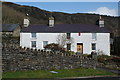
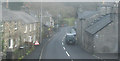
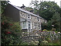
1
Cottages next to the former Garizim Chapel
Image: © Eric Jones
Taken: 7 Jul 2007
0.01 miles
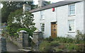
2
Elaborate gate in Penmorfa
A pedestrian entrance over a culvert.
Image: © Bill Boaden
Taken: 25 Mar 2012
0.02 miles
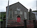
5
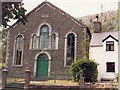
Zion chapel
The only remaining chapel in the village of Penmorfa
Image: © Dewi
Taken: Unknown
0.04 miles
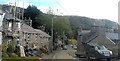
8
Railway Terrace, Penmorfa
In the 19th century the Gorseddau tramway ran past the front of these cottages- hence the name.
Image: © Dewi
Taken: 9 Sep 2007
0.08 miles
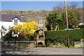
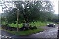
9
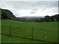
On the edge of Penmorfa village
A pretty good, if distant, view to the mountains; the Rhinogs I think.
Image: © Jeremy Bolwell
Taken: 24 Aug 2012
0.10 miles