IMAGES TAKEN NEAR TO
Rhyd, PENRHYNDEUDRAETH, LL48 6ST
Introduction
This page details the photographs taken nearby to LL48 6ST by members of the Geograph project.
The Geograph project started in 2005 with the aim of publishing, organising and preserving representative images for every square kilometre of Great Britain, Ireland and the Isle of Man.

There are currently over 7.5m images from over14,400 individuals and you can help contribute to the project by visiting https://www.geograph.org.uk
Image Map
Images are licensed for reuse under creativecommons.org/licenses/by-sa/2.0
Notes
- Clicking on the map will re-center to the selected point.
- The higher the marker number, the further away the image location is from the centre of the postcode.
Image Listing (25 Images Found)
Images are licensed for reuse under creativecommons.org/licenses/by-sa/2.0
Image
Details
Distance
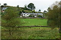
1
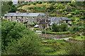
Rhyd, Gwynedd
Much of the hamlet, visible from the public footpath.
Image: © Peter Trimming
Taken: 23 Aug 2012
0.03 miles
2
Rhyd, Gwynedd
Much of the hamlet, seen from the public footpath.
Image: © Peter Trimming
Taken: 23 Aug 2012
0.03 miles
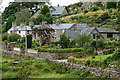
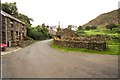
3
Rhyd, Gwynedd
Part of the hamlet, seen from the public footpath.
Image: © Peter Trimming
Taken: 23 Aug 2012
0.03 miles

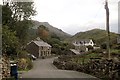
5
Rhyd
The village of Rhyd near Penrhyndeudraeth
Image: © Pierre Terre
Taken: 12 Aug 2000
0.06 miles
7
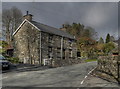
April Shower Clouds over Bodlondeb, Rhyd
Shower clouds gather over Bodlondeb, Rhyd in mid April.
Image: © Stephen Elwyn RODDICK
Taken: 15 Apr 2008
0.08 miles