IMAGES TAKEN NEAR TO
Llanfrothen, PENRHYNDEUDRAETH, LL48 6SP
Introduction
This page details the photographs taken nearby to LL48 6SP by members of the Geograph project.
The Geograph project started in 2005 with the aim of publishing, organising and preserving representative images for every square kilometre of Great Britain, Ireland and the Isle of Man.

There are currently over 7.5m images from over14,400 individuals and you can help contribute to the project by visiting https://www.geograph.org.uk
Image Map (Loading...)


Getting Data...Please wait
Leaflet Map data © OpenStreetMap
Images are licensed for reuse under creativecommons.org/licenses/by-sa/2.0
Notes
- Clicking on the map will re-center to the selected point.
- The higher the marker number, the further away the image location is from the centre of the postcode.
Image Listing (17 Images Found)
Images are licensed for reuse under creativecommons.org/licenses/by-sa/2.0
Image
Details
Distance
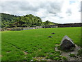
1
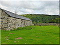
Farm buildings at Parc
The Walled Garden is behind the wall running across from the right.
Image: © David Medcalf
Taken: 8 Aug 2013
0.02 miles
3
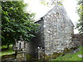
One of the two houses on the main site at Parc
Image: © David Medcalf
Taken: 8 Aug 2013
0.03 miles
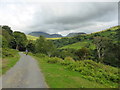
4

The lane to Parc
Looking north east, with Cnicht visible on the left and Moelwyn Mawr on the right.
Image: © David Medcalf
Taken: 8 Aug 2013
0.03 miles
5
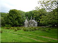
House at Parc
The ancient 'house' of Parc appears to be two houses, of which this is one. The other is just out of shot to the right. It was built in around 1600 as a home of the Anwyl family.
Image: © David Medcalf
Taken: 8 Aug 2013
0.05 miles
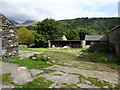
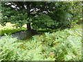
6
The Walled Garden at Parc
Used only for the recuperation of sick sheep, it seems. The garden slopes, not the photograph.
Image: © David Medcalf
Taken: 8 Aug 2013
0.05 miles
7
The line of the disused tramway
It is impossible to tell that this was once the route for delivering slate from the important Croesor Quarry.
Image: © David Medcalf
Taken: 8 Aug 2013
0.08 miles
8
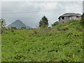
House above Parc
The OS map shows this house as being exactly on the line of the disused tramway. Known as The Drum House, it is a 1960s conversion for Lady Aberconway by the local architect Clough Williams-Ellis of one of the winding houses along the tramway.
Image: © David Medcalf
Taken: 8 Aug 2013
0.09 miles
9
The lane to Parc
Looking north east. Bwlch Stwlan between Moelwyn Mawr and Moelwyn Bach is on the horizon.
Image: © David Medcalf
Taken: 8 Aug 2013
0.12 miles
10
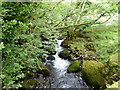
The Afon Croesor between Parc and Garth-y-foel
Taken from the bridge on the track.
Image: © David Medcalf
Taken: 8 Aug 2013
0.13 miles