IMAGES TAKEN NEAR TO
PENRHYNDEUDRAETH, LL48 6RT
Introduction
This page details the photographs taken nearby to LL48 6RT by members of the Geograph project.
The Geograph project started in 2005 with the aim of publishing, organising and preserving representative images for every square kilometre of Great Britain, Ireland and the Isle of Man.

There are currently over 7.5m images from over14,400 individuals and you can help contribute to the project by visiting https://www.geograph.org.uk
Image Map (Loading...)


Getting Data...Please wait
Leaflet Map data © OpenStreetMap
Images are licensed for reuse under creativecommons.org/licenses/by-sa/2.0
Notes
- Clicking on the map will re-center to the selected point.
- The higher the marker number, the further away the image location is from the centre of the postcode.
Image Listing (32 Images Found)
Images are licensed for reuse under creativecommons.org/licenses/by-sa/2.0
Image
Details
Distance
1
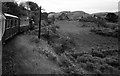
Festiniog Railway ? 1965
An up train headed by 'Prince' approaching Penrhyndeudraeth. The second carriage is the then new no.24 (later 104), the first of the new-build carriages to a larger loading gauge as can be seen from the higher roof line compared with the older stock.
Image: © Alan Murray-Rust
Taken: 12 Jun 1965
0.03 miles
3
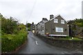
Road in Penrhyndeudraeth
A street of houses to the north of Penrhyndeudraeth.
Image: © DS Pugh
Taken: 20 Jul 2015
0.06 miles
4
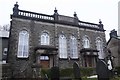
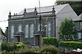
Nazareth Chapel
A Grade II Listed Building.
Converted into private residence's in recent times.
Image: © Arthur C Harris
Taken: 2 Feb 2020
0.08 miles
5
Nazareth Chapel, Penrhyndeudraeth, Gwynedd
The former chapel, having stood empty for some time, has been converted into two substantial houses. The tiny rear gardens bound onto the Ffestiniog Railway, giving close views of the passing trains.
Image: © Peter Trimming
Taken: 20 Aug 2012
0.09 miles
6

Spotted!
In Penrhyndeudraeth, the cat on the Morris had spotted the photographer; the latter having been attracted by the neighbouring chapel, which has been converted into accommodation. To the left of the picture is a public footpath, and the converted chapel lies to the left of the path.
Image: © Peter Trimming
Taken: 20 Aug 2012
0.10 miles
7
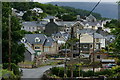
Penrhyndeudraeth, Gwynedd
Back streets, in Penrhyndeudraeth, showing the variety of buildings, old and new, in this village. Near the centre of picture, the foundations are in place for a new house.
Image: © Peter Trimming
Taken: 22 Aug 2012
0.10 miles
8

Road to Penrhyndeudraeth
Looking along a minor road from Minffordd to Penrhyndeudraeth also forming part of NCN8.
Image: © DS Pugh
Taken: 20 Jul 2015
0.11 miles
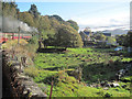
9

Pen y Bryn, Penrhyndeudraeth
Looking south from the Ffestiniog Railway.
Image: © Christine Johnstone
Taken: 31 May 2015
0.12 miles
10

Outskirts of Penrhyndeudraeth
Looking down the road which forms part of NCN8.
Image: © DS Pugh
Taken: 20 Jul 2015
0.17 miles