IMAGES TAKEN NEAR TO
Tan Y Banc, PENRHYNDEUDRAETH, LL48 6PT
Introduction
This page details the photographs taken nearby to Tan Y Banc, LL48 6PT by members of the Geograph project.
The Geograph project started in 2005 with the aim of publishing, organising and preserving representative images for every square kilometre of Great Britain, Ireland and the Isle of Man.

There are currently over 7.5m images from over14,400 individuals and you can help contribute to the project by visiting https://www.geograph.org.uk
Image Map
Images are licensed for reuse under creativecommons.org/licenses/by-sa/2.0
Notes
- Clicking on the map will re-center to the selected point.
- The higher the marker number, the further away the image location is from the centre of the postcode.
Image Listing (90 Images Found)
Images are licensed for reuse under creativecommons.org/licenses/by-sa/2.0
Image
Details
Distance
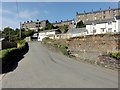
1
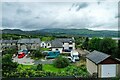
View across Penrhyndeudraeth
View across the Penlan area of Penrhyndeudraeth from the Ffestiniog Railway.
Image: © Jeff Buck
Taken: 28 Aug 2020
0.06 miles
2
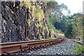
Ffestiniog Railway Track at Penrhyndeudraeth, Gwynedd
Track seen from a crossing point, about 200 yards before Penrhyn Station.
Image: © Peter Trimming
Taken: 10 Oct 2010
0.06 miles
3
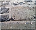
Ordnance Survey Cut Mark
This OS cut mark can be found on Cyneal, SE side of the A4085. It marks a point 26.707m above mean sea level.
Image: © Adrian Dust
Taken: 12 Oct 2018
0.06 miles
4

Bethel Capel y Bedyddwyr, Penrhyndeudraeth
Image: © Arthur C Harris
Taken: 21 Aug 2014
0.08 miles
5
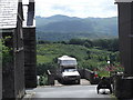
Penrhyndeudraeth, Wales
Wouldn't want to get that reverse park wrong!
Image: © easthantsxc
Taken: 25 Jun 2013
0.09 miles
6
Penrhyndeudraeth - 2013
Penrhyndeudraeth, Gwynedd, Pool Street
Image: © Helmut Zozmann
Taken: 22 Aug 2013
0.09 miles

8

Spotted!
In Penrhyndeudraeth, the cat on the Morris had spotted the photographer; the latter having been attracted by the neighbouring chapel, which has been converted into accommodation. To the left of the picture is a public footpath, and the converted chapel lies to the left of the path.
Image: © Peter Trimming
Taken: 20 Aug 2012
0.11 miles
9

Pen y Bryn, Penrhyndeudraeth
Looking south from the Ffestiniog Railway.
Image: © Christine Johnstone
Taken: 31 May 2015
0.11 miles
10
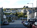
Penrhyndeudraeth
View of the upper part of the town from the lower part.
Image: © Peter Trimming
Taken: 1 May 2008
0.12 miles