IMAGES TAKEN NEAR TO
Soar, TALSARNAU, LL47 6UT
Introduction
This page details the photographs taken nearby to LL47 6UT by members of the Geograph project.
The Geograph project started in 2005 with the aim of publishing, organising and preserving representative images for every square kilometre of Great Britain, Ireland and the Isle of Man.

There are currently over 7.5m images from over14,400 individuals and you can help contribute to the project by visiting https://www.geograph.org.uk
Image Map
Images are licensed for reuse under creativecommons.org/licenses/by-sa/2.0
Notes
- Clicking on the map will re-center to the selected point.
- The higher the marker number, the further away the image location is from the centre of the postcode.
Image Listing (10 Images Found)
Images are licensed for reuse under creativecommons.org/licenses/by-sa/2.0
Image
Details
Distance
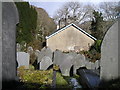
3
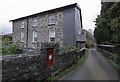
Capel Soar
A Grade II listed building.
Image: © Arthur C Harris
Taken: 13 Dec 2018
0.01 miles
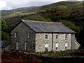
4
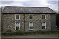
Soar Chapel
View of Soar (Wesleyan) Chapel, looking south east from Garth, with Coed Maes y Neuadd in background.
Image: © David Saunders
Taken: 28 Mar 2005
0.04 miles
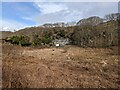
8
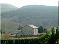
View over Soar looking north-east
View towards Llandecwyn, showing TV mast on ridge in far distance. The valley Afon-y-Glyn is below the hamlet to the East.
Image: © David Saunders
Taken: 10 Apr 2004
0.06 miles
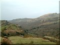
9
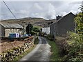
Wet road in the rain
Looking along the road between Eisingrug and Bryn Bwbach which also forms part of National Cycle Network route 8.
Image: © DS Pugh
Taken: 20 Jul 2015
0.21 miles
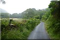
10

Road near Coed Maes-y-neuadd
Looking along the road between Eisingrug and Bryn Bwbach which also forms part of National Cycle Network route 8.
Image: © DS Pugh
Taken: 20 Jul 2015
0.23 miles