IMAGES TAKEN NEAR TO
Glan Gors, HARLECH, LL46 2SQ
Introduction
This page details the photographs taken nearby to Glan Gors, LL46 2SQ by members of the Geograph project.
The Geograph project started in 2005 with the aim of publishing, organising and preserving representative images for every square kilometre of Great Britain, Ireland and the Isle of Man.

There are currently over 7.5m images from over14,400 individuals and you can help contribute to the project by visiting https://www.geograph.org.uk
Image Map
Images are licensed for reuse under creativecommons.org/licenses/by-sa/2.0
Notes
- Clicking on the map will re-center to the selected point.
- The higher the marker number, the further away the image location is from the centre of the postcode.
Image Listing (39 Images Found)
Images are licensed for reuse under creativecommons.org/licenses/by-sa/2.0
Image
Details
Distance
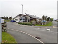
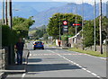
2
Beside the A496 road
Running into lower Harlech.
Image: © John Lucas
Taken: 8 Jun 2022
0.04 miles
3
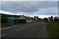
Bus stop on Ffordd Morfa
Looking along the A496 in Harlech.
Image: © DS Pugh
Taken: 3 Aug 2023
0.05 miles
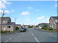
4
North along the A496 Ffordd Morfa in Harlech
Image: © Mat Fascione
Taken: 19 Jun 2012
0.08 miles
5
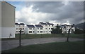
Glan Gors, Harlech
Roughly translated as swampy shore. Flats on the flat land between Harlech and the dunes.
Image: © E Gammie
Taken: 15 Oct 1987
0.08 miles
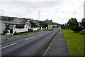
6
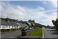
Lower Harlech
Y Waun is to the left with the castle prominent ahead.
Image: © DS Pugh
Taken: 20 Jul 2015
0.09 miles
7
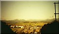
O Harlech i'r Wyddfa/From Harlech to Snowdon
Image: © G Williams
Taken: 4 Aug 2005
0.09 miles
9
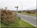
Sign for the Wales Coast Path
The path leaves the A496 and heads west
Image: © Eirian Evans
Taken: 15 May 2018
0.11 miles