IMAGES TAKEN NEAR TO
HARLECH, LL46 2RB
Introduction
This page details the photographs taken nearby to LL46 2RB by members of the Geograph project.
The Geograph project started in 2005 with the aim of publishing, organising and preserving representative images for every square kilometre of Great Britain, Ireland and the Isle of Man.

There are currently over 7.5m images from over14,400 individuals and you can help contribute to the project by visiting https://www.geograph.org.uk
Image Map (136 Images)


Getting Data...Please wait
Leaflet Map data © OpenStreetMap
Images are licensed for reuse under creativecommons.org/licenses/by-sa/2.0
Notes
- Clicking on the map will re-center to the selected point.
- The higher the marker number, the further away the image location is from the centre of the postcode.
Image Listing (136 Images Found)
Images are licensed for reuse under creativecommons.org/licenses/by-sa/2.0
Image
Details
Distance
1
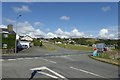
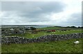
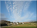
Meeting the A496
Looking over the A496 towards Llanfair from the Llandanwg road.
Image: © DS Pugh
Taken: 30 Jul 2018
0.01 miles
3
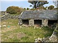
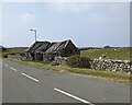
Animal shelter at Llanfair
Perhaps originally a pigsty.
Image: © David Medcalf
Taken: 21 Apr 2021
0.02 miles

5
Sign for Llandanwg
Looking over fields between Llanfair and Llandanwg.
Image: © DS Pugh
Taken: 30 Jul 2018
0.03 miles
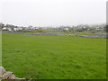
6
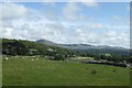
Fields near Llanfair
Looking across farmland from the A496.
Image: © DS Pugh
Taken: 3 Aug 2023
0.04 miles
7
Field in Llanfair
With views towards the Rhinogs.
Image: © DS Pugh
Taken: 30 Jul 2018
0.05 miles
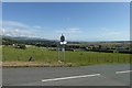
10
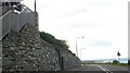
Llanfair
From the road to Llandanwg.
Image: © Peter Humphreys
Taken: 2 Mar 2008
0.06 miles