IMAGES TAKEN NEAR TO
LLANBEDR, LL45 2PL
Introduction
This page details the photographs taken nearby to LL45 2PL by members of the Geograph project.
The Geograph project started in 2005 with the aim of publishing, organising and preserving representative images for every square kilometre of Great Britain, Ireland and the Isle of Man.

There are currently over 7.5m images from over14,400 individuals and you can help contribute to the project by visiting https://www.geograph.org.uk
Image Map
Images are licensed for reuse under creativecommons.org/licenses/by-sa/2.0
Notes
- Clicking on the map will re-center to the selected point.
- The higher the marker number, the further away the image location is from the centre of the postcode.
Image Listing (18 Images Found)
Images are licensed for reuse under creativecommons.org/licenses/by-sa/2.0
Image
Details
Distance
1
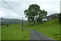
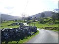
Road passing Pen-isa'r-cwm
The road passing the collection of farm buildings at Pen-isa'r-cwm.
Image: © DS Pugh
Taken: 3 Aug 2023
0.02 miles
2

Ardudwy Way signpost
On side of country road, near Pen-isa'r-cwm (farmhouse)
Image: © Michael Westley
Taken: 10 Jul 2011
0.03 miles
3
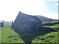
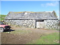
Little stone barn at Penisarcwm farm, Cwmnantcol
What a tiny little gem in the morning light.
Image: © Jeremy Bolwell
Taken: 11 Apr 2015
0.04 miles
4
Penisarcwm hillside and Foel Ddu
Hillside walk to viewpoint - in background, Rhinog range of mountains (Foel Ddu)
Image: © Michael Westley
Taken: 10 Jul 2011
0.04 miles
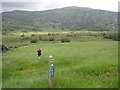
5
Ardudwy Way route
View of mountainside beyond route of Ardudwy Way. This section is diverted from Right of Way, instead is a permissive footpath
Image: © Michael Westley
Taken: 10 Jul 2011
0.05 miles
6
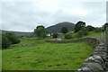
Wall near Pen-isa'r-cwm
Looking from the road into a field near the farm.
Image: © DS Pugh
Taken: 3 Aug 2023
0.08 miles
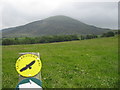
7
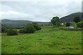
Fields near Pen-isa'r-cwm
Fields below the farm along the road from Pentre Gwynfryn.
Image: © DS Pugh
Taken: 3 Aug 2023
0.08 miles
8
Penisarcwm farm below Cwm Nantcol
What a lovely valley this truly is.
Image: © Jeremy Bolwell
Taken: 11 Apr 2015
0.11 miles
9
Big old barn above Penisarcwm farm, Cwm Nantcol
What a lovely old structure.
Image: © Jeremy Bolwell
Taken: 11 Apr 2015
0.15 miles
10
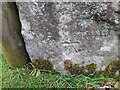
Ordnance Survey Cut Mark
This OS cut mark can be found on the stone at the wall junction. It marks a point 145.207m above mean sea level.
Image: © Adrian Dust
Taken: 16 Oct 2022
0.16 miles