IMAGES TAKEN NEAR TO
LLANBEDR, LL45 2HL
Introduction
This page details the photographs taken nearby to LL45 2HL by members of the Geograph project.
The Geograph project started in 2005 with the aim of publishing, organising and preserving representative images for every square kilometre of Great Britain, Ireland and the Isle of Man.

There are currently over 7.5m images from over14,400 individuals and you can help contribute to the project by visiting https://www.geograph.org.uk
Image Map
Images are licensed for reuse under creativecommons.org/licenses/by-sa/2.0
Notes
- Clicking on the map will re-center to the selected point.
- The higher the marker number, the further away the image location is from the centre of the postcode.
Image Listing (67 Images Found)
Images are licensed for reuse under creativecommons.org/licenses/by-sa/2.0
Image
Details
Distance
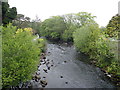
1
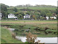
Looking across the River Artro towards Llanbedr
While walking along the Wales Coast Path
Image: © Eirian Evans
Taken: 15 May 2018
0.06 miles
2
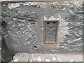
Ordnance Survey Flush Bracket (12055)
This OS Flush Bracket can be found on Glanrafon. It marks a point 6.183m above mean sea level.
Image: © Adrian Dust
Taken: 16 Oct 2022
0.10 miles
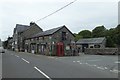
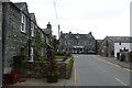
3
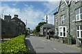
Houses in Llanbedr
Looking along the A496 in the village of Llanbedr.
Image: © DS Pugh
Taken: 29 Jul 2023
0.10 miles

7
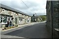
A496 in Llanbedr
Looking towards the bridge over the Afon Artro.
Image: © DS Pugh
Taken: 29 Jul 2023
0.12 miles
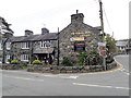
8
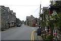
Victoria Inn
Llanbedr seen from the bridge over the Artro.
Image: © DS Pugh
Taken: 21 Jul 2015
0.13 miles
10
Llanbedr village
On the road from Pentre Gwynfryn.
Image: © DS Pugh
Taken: 21 Jul 2015
0.13 miles