IMAGES TAKEN NEAR TO
Ffordd Yr Orsaf, DYFFRYN ARDUDWY, LL44 2EE
Introduction
This page details the photographs taken nearby to Ffordd Yr Orsaf, LL44 2EE by members of the Geograph project.
The Geograph project started in 2005 with the aim of publishing, organising and preserving representative images for every square kilometre of Great Britain, Ireland and the Isle of Man.

There are currently over 7.5m images from over14,400 individuals and you can help contribute to the project by visiting https://www.geograph.org.uk
Image Map
Images are licensed for reuse under creativecommons.org/licenses/by-sa/2.0
Notes
- Clicking on the map will re-center to the selected point.
- The higher the marker number, the further away the image location is from the centre of the postcode.
Image Listing (16 Images Found)
Images are licensed for reuse under creativecommons.org/licenses/by-sa/2.0
Image
Details
Distance
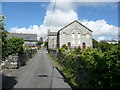
1
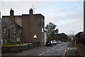
Ffordd yr Orsaf (Station Road)
Cottages and some strange brutalist architecture!
Image: © Trevor Harris
Taken: 11 Sep 2019
0.00 miles
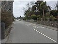
2
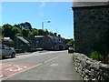
Main road through Dyffryn Ardudwy
Looking south down the main road from the corner of Station Road
Image: © Eirian Evans
Taken: 7 Jun 2013
0.04 miles
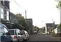
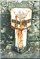
7
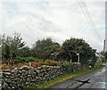
Footpath Sign on Ffordd Isaf (Lower Road)
Image: © PAUL FARMER
Taken: 6 Oct 2020
0.09 miles
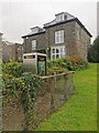
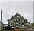
8
Large chapel building in Dyffryn Ardudwy
This substantial place of worship was once no doubt a very important building in the village and a centre of life there.
Image: © Jeremy Bolwell
Taken: 29 Jun 2011
0.11 miles
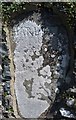
9
Old Milepost by the A496, Y Brif Heol, Dyffryn Ardudwy
Merioneth bevel by the A496, in parish of Dyffryn Ardudwy (Gwynedd District), Dyffryn Ardudwy, opposite filling station against wall, West side of road.
Inscription reads:-
: HARLECH / 5 : : BARMOUTH / 5 :
Grade II listed by Cadw.
Reference Number 84356: https://cadwpublic-api.azurewebsites.net/reports/listedbuilding/FullReport?lang=&id=84356
Surveyed
Milestone Society National ID: MER_HLBM05A
Image: © Milestone Society
Taken: Unknown
0.13 miles
10
Milestone - Harlech 5
Built into wall east side of road.
Image: © Adrian Dust
Taken: 29 Jul 2019
0.14 miles