IMAGES TAKEN NEAR TO
DYFFRYN ARDUDWY, LL44 2DA
Introduction
This page details the photographs taken nearby to LL44 2DA by members of the Geograph project.
The Geograph project started in 2005 with the aim of publishing, organising and preserving representative images for every square kilometre of Great Britain, Ireland and the Isle of Man.

There are currently over 7.5m images from over14,400 individuals and you can help contribute to the project by visiting https://www.geograph.org.uk
Image Map
Images are licensed for reuse under creativecommons.org/licenses/by-sa/2.0
Notes
- Clicking on the map will re-center to the selected point.
- The higher the marker number, the further away the image location is from the centre of the postcode.
Image Listing (5 Images Found)
Images are licensed for reuse under creativecommons.org/licenses/by-sa/2.0
Image
Details
Distance

3
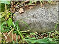
Ordnance Survey Pivot
This OS pivot can be found on the step of the stile NW side of the road. It marks a point 69.912m above mean sea level.
Image: © Adrian Dust
Taken: 16 Oct 2022
0.19 miles
4
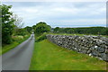
Lon gul uwchben Coed Ystumgwern / Narrow lane above Coed Ystumgwern
Yn edrych i lawr y lon uwchben Coed Ystumgwern tuag at y mor / Looking down the road above Coed Ystumgwern towards the sea.
Image: © Ian Medcalf
Taken: 29 May 2014
0.22 miles
5
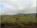
Across the fields towards Cwm Ystumgwern
From the railway north of Dyffryn station
Image: © John Firth
Taken: 23 Oct 2012
0.23 miles