IMAGES TAKEN NEAR TO
DYFFRYN ARDUDWY, LL44 2BS
Introduction
This page details the photographs taken nearby to LL44 2BS by members of the Geograph project.
The Geograph project started in 2005 with the aim of publishing, organising and preserving representative images for every square kilometre of Great Britain, Ireland and the Isle of Man.

There are currently over 7.5m images from over14,400 individuals and you can help contribute to the project by visiting https://www.geograph.org.uk
Image Map
Images are licensed for reuse under creativecommons.org/licenses/by-sa/2.0
Notes
- Clicking on the map will re-center to the selected point.
- The higher the marker number, the further away the image location is from the centre of the postcode.
Image Listing (4 Images Found)
Images are licensed for reuse under creativecommons.org/licenses/by-sa/2.0
Image
Details
Distance

3
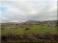
Looking across the dunes
About 9am on a morning just after Easter, from an upstairs room of a holiday home
Image: © Ian Cardinal
Taken: 11 Apr 2007
0.20 miles
4
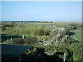
Across the fields towards Cwm Ystumgwern
From the railway north of Dyffryn station
Image: © John Firth
Taken: 23 Oct 2012
0.21 miles