IMAGES TAKEN NEAR TO
TALYBONT, LL43 2BJ
Introduction
This page details the photographs taken nearby to LL43 2BJ by members of the Geograph project.
The Geograph project started in 2005 with the aim of publishing, organising and preserving representative images for every square kilometre of Great Britain, Ireland and the Isle of Man.

There are currently over 7.5m images from over14,400 individuals and you can help contribute to the project by visiting https://www.geograph.org.uk
Image Map
Images are licensed for reuse under creativecommons.org/licenses/by-sa/2.0
Notes
- Clicking on the map will re-center to the selected point.
- The higher the marker number, the further away the image location is from the centre of the postcode.
Image Listing (9 Images Found)
Images are licensed for reuse under creativecommons.org/licenses/by-sa/2.0
Image
Details
Distance
2
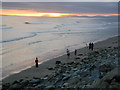
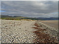
Beach near Tal-y-Bont
With the sun setting behind the Llŷn Peninsula (as in Image)
Image: © Roger W Haworth
Taken: 22 Jul 2006
0.14 miles
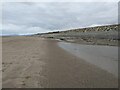
3
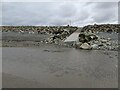
Access area through the sea defences
The road through the holiday park ends above this shingle bank which allows beach access.
Image: © David Medcalf
Taken: 7 Apr 2021
0.15 miles

5

Sarnfaen farmhouse
The farmhouse now sits between a caravan park and a holiday park
Image: © Eirian Evans
Taken: 22 Oct 2022
0.19 miles
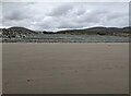
7
Tal-y-Bont Beach
A view towards Barmouth.
Image: © Tim Bartlett
Taken: 26 Sep 2010
0.21 miles
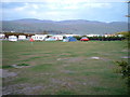
9
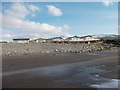
Chalets in the Holiday Village
Modern holiday chalets on the beach front, I wonder what it's like in a westerly storm?
Image: © John Haynes
Taken: 2 Feb 2012
0.23 miles