IMAGES TAKEN NEAR TO
BARMOUTH, LL42 1TE
Introduction
This page details the photographs taken nearby to LL42 1TE by members of the Geograph project.
The Geograph project started in 2005 with the aim of publishing, organising and preserving representative images for every square kilometre of Great Britain, Ireland and the Isle of Man.

There are currently over 7.5m images from over14,400 individuals and you can help contribute to the project by visiting https://www.geograph.org.uk
Image Map (Loading...)


Getting Data...Please wait
Leaflet Map data © OpenStreetMap
Images are licensed for reuse under creativecommons.org/licenses/by-sa/2.0
Notes
- Clicking on the map will re-center to the selected point.
- The higher the marker number, the further away the image location is from the centre of the postcode.
Image Listing (99 Images Found)
Images are licensed for reuse under creativecommons.org/licenses/by-sa/2.0
Image
Details
Distance
1
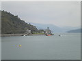
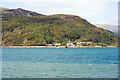
Coes-faen from Barmouth Bridge
A telephoto shot of a small settlement on the A496 east of Barmouth, on the shore of the Mawddach estuary. The mist is giving the mountains inland that lovely layered effect.
Image: © Richard Vince
Taken: 3 Oct 2015
0.02 miles
3
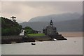
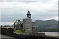
Property overlooking the Mawddach near Barmouth
I believe that this amazing property is called Coes Faen and is also known as 'the Clock Tower' and is a well known landmark overlooking the Mawddach estuary near Barmouth. It is in an eclectic Victorian Gothic style, built by the Lowe family of mill-owners and dates from the 1840's, with additions including the striking clock tower, added around 1890. The chimes are very pleasing and carry well over the estuary.
Image: © Jeremy Bolwell
Taken: 25 Jul 2012
0.03 miles
4
Coesfaen Hall
Prominently sited on a natural projection into the Mawddach estuary, immediately to the south of the main road, and some 300m east of Barmouth railway bridge. This eclectic Victorian Gothic house was built by the Lowe family, mill-owners; the main, central section dates from c.1844, to which additions including a striking clock tower were added c.1890-1900. It is now a hotel.
Image: © Eirian Evans
Taken: 10 May 2012
0.03 miles
5
Coes Faen Hall (The Clock House) by the A496 Barmouth
Grade II Listed house built by the Lowe family, who were mill-owners. The main section was built in 1844 on the site of an earlier medieval house. The clock tower was added in 1890-1900.
Image: © Jo and Steve Turner
Taken: 28 Jun 2011
0.03 miles
6
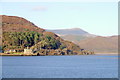
The Mawddach Estuary
Looking across the estuary to Coes-faen, from Barmouth bridge.
Image: © Kevin Williams
Taken: 8 Jan 2011
0.03 miles
7
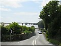
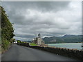
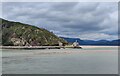
A496 approaching Barmouth
A view along the A496 road as it approaches the seaside town of Barmouth.
Barmouth Bridge, which carries the Cambrian Coast railway line across the estuary, is visible in the background.
Image: © Malc McDonald
Taken: 6 Aug 2023
0.03 miles
8
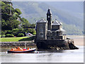
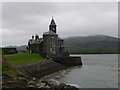
The Clock House
The Clock House,Barmouth, Gwynedd
Image: © Arthur C Harris
Taken: 25 Jun 2012
0.03 miles
9
Caes-faen (The Clock House) beneath Ffridd Gorllwyn
Viewed across the Mawddach Estuary from Barmouth Bridge. The Clock House is currently being offered for sale for a price just in excess of £2m.
Image: © John Lucas
Taken: 1 Sep 2022
0.03 miles
10
Coes Faen on the Mawddach estuary
This Victorian Gothic house was built by the Lowe family, who were mill-owners. The main section was built in 1844, the clock tower was added in 1890-1900.
Image: © Mat Fascione
Taken: 15 Jul 2022
0.03 miles