IMAGES TAKEN NEAR TO
Northfield Road, BARMOUTH, LL42 1PY
Introduction
This page details the photographs taken nearby to Northfield Road, LL42 1PY by members of the Geograph project.
The Geograph project started in 2005 with the aim of publishing, organising and preserving representative images for every square kilometre of Great Britain, Ireland and the Isle of Man.

There are currently over 7.5m images from over14,400 individuals and you can help contribute to the project by visiting https://www.geograph.org.uk
Image Map
Images are licensed for reuse under creativecommons.org/licenses/by-sa/2.0
Notes
- Clicking on the map will re-center to the selected point.
- The higher the marker number, the further away the image location is from the centre of the postcode.
Image Listing (102 Images Found)
Images are licensed for reuse under creativecommons.org/licenses/by-sa/2.0
Image
Details
Distance
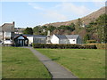
1
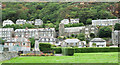
War memorial at Barmouth
The memorial is beyond the flower bed at the left side of the image. Large houses and / or guest houses occupy the rising slope beyond.
Image: © Trevor Littlewood
Taken: 6 Sep 2018
0.03 miles
2
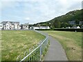
Path beside the bowling club
The path runs between Epworth Road and Northfield Road.
Image: © DS Pugh
Taken: 4 Aug 2023
0.04 miles
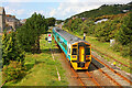
4
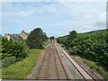
Lines out of Barmouth
Looking north from the Epworth Footbridge.
Image: © Gerald England
Taken: 13 Jul 2023
0.06 miles
5
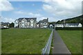
Barmouth Bowling Club
From Bryn Mynach Road.
Image: © M J Richardson
Taken: 4 Mar 2011
0.06 miles
6
Railway at Barmouth
View from the footbridge in Barmouth.
Image: © Wayland Smith
Taken: 27 Aug 2010
0.07 miles
7
Houses on Bryn Mynach Road
In this distance is the footbridge over the railway line.
Image: © DS Pugh
Taken: 4 Aug 2023
0.07 miles
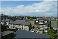
9
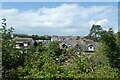
Above Bryn Mynach Road
Looking over rooftops from Kings Crescent.
Image: © DS Pugh
Taken: 4 Aug 2023
0.08 miles
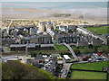
10
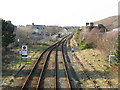
The railway north from Barmouth
The station is just to the south, and double tracked; here the track becomes single as it heads to Harlech. Viewed from the footbridge linking Park Road and Marine Gardens.
Image: © M J Richardson
Taken: 4 Mar 2011
0.08 miles