IMAGES TAKEN NEAR TO
King Edward Street, BARMOUTH, LL42 1NY
Introduction
This page details the photographs taken nearby to King Edward Street, LL42 1NY by members of the Geograph project.
The Geograph project started in 2005 with the aim of publishing, organising and preserving representative images for every square kilometre of Great Britain, Ireland and the Isle of Man.

There are currently over 7.5m images from over14,400 individuals and you can help contribute to the project by visiting https://www.geograph.org.uk
Image Map
Images are licensed for reuse under creativecommons.org/licenses/by-sa/2.0
Notes
- Clicking on the map will re-center to the selected point.
- The higher the marker number, the further away the image location is from the centre of the postcode.
Image Listing (260 Images Found)
Images are licensed for reuse under creativecommons.org/licenses/by-sa/2.0
Image
Details
Distance
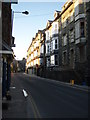
1
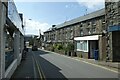
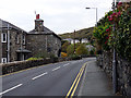
King Edward's Street
Part of the A496 in Barmouth.
Image: © DS Pugh
Taken: 4 Aug 2023
0.01 miles
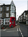
2
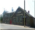
Llys Ynadon Magistrates Court
Former Magistrates Court on King Edward's Street, dated 1906. Now a private residence.
Image: © Gerald England
Taken: 13 Jul 2023
0.02 miles
3
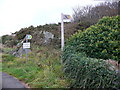
Taith Ardudwy / Ardudwy Trail
Lle cychwyn Taith Ardudwy (Y Bermo) / Starting place, Ardudwy Trail (Barmouth).
Image: © Ian Medcalf
Taken: 24 Sep 2011
0.03 miles
5
King Edward St. looking north from the front of the Royal Hotel
Image: © David Bowen
Taken: 16 Feb 2008
0.04 miles
6
'The Royal'
In King Edward's Street, Barmouth. Just what I needed after walking the Wales Coast Path from Dyffryn Ardudwy!
Image: © John Lucas
Taken: 26 Oct 2015
0.06 miles
7
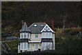
House on Hill in Barmouth
View of prominent house on Hill in Barmouth, Wales.
Image: © Simon Fidler
Taken: 31 Dec 2007
0.06 miles
8
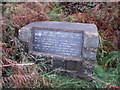
Hidden tribute on a Barmouth hillside
From the town walk up the road leading to St John's church, at the end of the victorian terraced villas turn left up the very steep road till you reach the crest. On your right you will see a grassy public footpath running level towards the church. Around 5 paces down the path there is just visible a little 'fox' path to your left that takes you to a little knoll of rock overlooking the path where it joined the road. Here you will find a wonderful view of the church as painted by Keeley-Braiser. See other slide from same grid.
Picture 27th October 2007.
Image: © David Bowen
Taken: 27 Oct 2007
0.06 miles
10
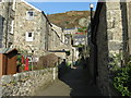
Bryn Mynach Road
The alley giving access to the backs of the houses, from Park Road.
Image: © M J Richardson
Taken: 4 Mar 2011
0.07 miles