IMAGES TAKEN NEAR TO
Gibraltar Lane, BARMOUTH, LL42 1DB
Introduction
This page details the photographs taken nearby to Gibraltar Lane, LL42 1DB by members of the Geograph project.
The Geograph project started in 2005 with the aim of publishing, organising and preserving representative images for every square kilometre of Great Britain, Ireland and the Isle of Man.

There are currently over 7.5m images from over14,400 individuals and you can help contribute to the project by visiting https://www.geograph.org.uk
Image Map (Loading...)


Getting Data...Please wait
Leaflet Map data © OpenStreetMap
Images are licensed for reuse under creativecommons.org/licenses/by-sa/2.0
Notes
- Clicking on the map will re-center to the selected point.
- The higher the marker number, the further away the image location is from the centre of the postcode.
Image Listing (684 Images Found)
Images are licensed for reuse under creativecommons.org/licenses/by-sa/2.0
Image
Details
Distance
1

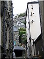
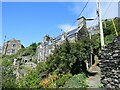
Linda's shop Barmouth Harbour
Looking up the 'Rock' above Linda's shop opposite St David's Church, High St, Barmouth. Picture 11.00 28th October 2007.
Image: © David Bowen
Taken: 28 Oct 2007
0.01 miles
2
Looking up at Barmouth
Tiny houses cling to the hill side.
Image: © Maigheach-gheal
Taken: 9 Oct 2008
0.01 miles
3
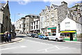
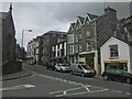
High Street (A496) at Barmouth
The junction with High Street and the promenade road at Barmouth.
Wikipedia https://en.wikipedia.org/wiki/Barmouth
Image: © Jeff Buck
Taken: 9 Aug 2016
0.02 miles
4
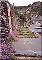
Steps through Old Barmouth
There are several routes upwards through the houses clinging to the rock all of which are steep!
Image: © E Gammie
Taken: 24 Jun 1999
0.02 miles
5
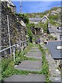
Steps through Old Barmouth
One of the several routes through the old part of Barmouth clinging to the rock. A railing has been added since 1999, see http://www.geograph.org.uk/photo/1316023 for comparison.
Image: © E Gammie
Taken: 12 May 2009
0.02 miles
6
Path and stone cottages, Barmouth
A path climbing past stone cottages on the steep hillside overlooking Barmouth.
Image: © Malc McDonald
Taken: 9 Aug 2023
0.02 miles
8
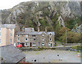
Houses below the cliffs in Church Street
Image: © John Firth
Taken: 23 Oct 2012
0.02 miles
9
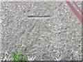
Bench mark on St David's church, Barmouth
This Ordnance Survey cut bench mark is near the north east corner of St David's church. See also Image
Image: © John S Turner
Taken: 3 Nov 2015
0.02 miles
10
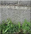
Ordnance Survey Cut Mark
This OS cut mark can be found on the NE face of St David's Church. It marks a point 6.853m above mean sea level.
Image: © Adrian Dust
Taken: 10 May 2016
0.02 miles