IMAGES TAKEN NEAR TO
Trawsfynydd, BLAENAU FFESTINIOG, LL41 4YD
Introduction
This page details the photographs taken nearby to LL41 4YD by members of the Geograph project.
The Geograph project started in 2005 with the aim of publishing, organising and preserving representative images for every square kilometre of Great Britain, Ireland and the Isle of Man.

There are currently over 7.5m images from over14,400 individuals and you can help contribute to the project by visiting https://www.geograph.org.uk
Image Map
Images are licensed for reuse under creativecommons.org/licenses/by-sa/2.0
Notes
- Clicking on the map will re-center to the selected point.
- The higher the marker number, the further away the image location is from the centre of the postcode.
Image Listing (6 Images Found)
Images are licensed for reuse under creativecommons.org/licenses/by-sa/2.0
Image
Details
Distance
1
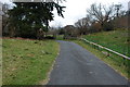
Capel Eden.
Nid pawb sy'n cael dweud "Eden" wrth ateb y ffôn!
Not many people can say "Eden" when they answer the 'phone!
Image: © Gerallt Pennant
Taken: 6 Apr 2007
0.03 miles
2

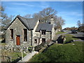
Ordnance Survey Flush Bracket (S0316)
This OS Flush Bracket can be found on Capel Eden Cottage. It marks a point 186.754m above mean sea level.
Image: © Adrian Dust
Taken: 11 May 2018
0.05 miles
3
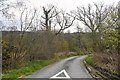
Trawsfynydd : Lane
A small lane off the A470.
Image: © Lewis Clarke
Taken: 22 Apr 2024
0.08 miles
4
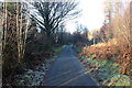
Forest track at Bryn Eden
Looking north along a forest track at the north of Coed-y-Brenin near Bryn Eden.
Wikipedia https://en.wikipedia.org/wiki/Coed-y-Brenin
Image: © Jeff Buck
Taken: 28 Dec 2016
0.15 miles
5
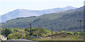
Cader Idris
The northern cliffs of Cader Idris dominate the view on the drive south towards Dolgellau.
Image: © Chris Denny
Taken: 29 May 2007
0.20 miles