IMAGES TAKEN NEAR TO
Market Square, BLAENAU FFESTINIOG, LL41 3HW
Introduction
This page details the photographs taken nearby to Market Square, LL41 3HW by members of the Geograph project.
The Geograph project started in 2005 with the aim of publishing, organising and preserving representative images for every square kilometre of Great Britain, Ireland and the Isle of Man.

There are currently over 7.5m images from over14,400 individuals and you can help contribute to the project by visiting https://www.geograph.org.uk
Image Map
Images are licensed for reuse under creativecommons.org/licenses/by-sa/2.0
Notes
- Clicking on the map will re-center to the selected point.
- The higher the marker number, the further away the image location is from the centre of the postcode.
Image Listing (337 Images Found)
Images are licensed for reuse under creativecommons.org/licenses/by-sa/2.0
Image
Details
Distance
1
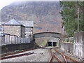
Blaenau Ffestiniog Footbridge
Footbridge over the line at the North end of the current station viewed Northwards.
Image: © John Charlton
Taken: 20 Feb 2007
0.01 miles
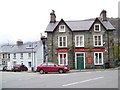
2
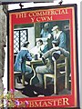
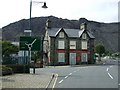
Sign for the Commercial, Blaenau Ffestiniog
These were pubs where commercial travellers used to gather in times gone by.
Image: © Maigheach-gheal
Taken: 9 Oct 2008
0.02 miles
3
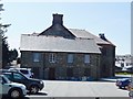
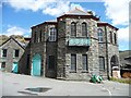
Market Place and factory
The former Town Hall.
Image: © John M
Taken: 11 Jul 2013
0.02 miles
4
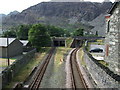
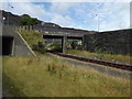
Rail tracks from Blaenau Ffestiniog
On the left the narrow gauge Ffestiniog line to / from Porthmadog, on the right the mainline to / from Llandudno Junction, both passing beneath the A496 road.
Image: © Richard Hoare
Taken: 7 Sep 2009
0.02 miles
5
The Commercial Pub at Blaenau Ffestiniog
As you can see no longer commercial as it is currently for sale. Perhaps a sign of current times particularly as Trish Steel photographed this same pub in October last year (2008) when it was in business. See Image
Image: © Richard Hoare
Taken: 7 Sep 2009
0.02 miles

7
Road bridge over railway
The line heads to Llandudno, whilst the Ffestiniog railway train from which this was taken is bound for Porthmadog.
Image: © Richard Hoare
Taken: 21 Jul 2014
0.03 miles
8
Former Town Hall, Blaenau Ffestiniog
The small building to the left [north] is 'the factory', where women did war work in both World Wars. The pavement nearby is carved 'Hwre i ferched yr hall!' in their honour [Hurrah for the women of the hall].
Image: © Christine Johnstone
Taken: 29 May 2015
0.03 miles
9
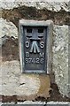
Ordnance Survey Flush Bracket (S7426)
This OS Flush Bracket can be found on the south face of St David's Church. It marks a point 217.591m above mean sea level.
Image: © Adrian Dust
Taken: 11 May 2016
0.03 miles
10
The Commercial, Blaenau Ffestiniog
The pub is on the outskirts of the town.
Image: © Maigheach-gheal
Taken: 9 Oct 2008
0.03 miles