IMAGES TAKEN NEAR TO
Tai'r Gelli, BLAENAU FFESTINIOG, LL41 3EW
Introduction
This page details the photographs taken nearby to Tai'r Gelli, LL41 3EW by members of the Geograph project.
The Geograph project started in 2005 with the aim of publishing, organising and preserving representative images for every square kilometre of Great Britain, Ireland and the Isle of Man.

There are currently over 7.5m images from over14,400 individuals and you can help contribute to the project by visiting https://www.geograph.org.uk
Image Map
Images are licensed for reuse under creativecommons.org/licenses/by-sa/2.0
Notes
- Clicking on the map will re-center to the selected point.
- The higher the marker number, the further away the image location is from the centre of the postcode.
Image Listing (75 Images Found)
Images are licensed for reuse under creativecommons.org/licenses/by-sa/2.0
Image
Details
Distance
1
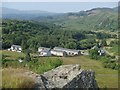
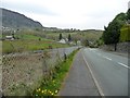
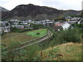
Cwm Bowydd view
Looking down the valley from a footpath with fine views above the main road.
Image: © Andrew Hill
Taken: 2 Jul 2014
0.01 miles
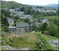
2
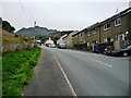
Houses at the end of Ffordd Cwmbowydd
The end of this part of residential Blaenau Ffestiniog.
Image: © Christine Johnstone
Taken: 30 Apr 2017
0.04 miles
3
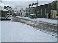
Blaenau Ffestiniog in the snow
Early spring in Snowdonia
Image: © gwyn
Taken: 1 Mar 2006
0.07 miles
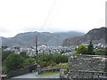
5
Ffordd Cwmbowydd, dropping down to Tai'r Gelli
This suburban Blaenau Ffestiniog road ends at a small housing estate.
Image: © Christine Johnstone
Taken: 30 Apr 2017
0.09 miles
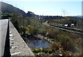
6
The now disused Tan-y-Manod railway viaduct
This stone viaduct on the Blaenau to Bala line was built to accommodate a standard gauge line, replacing a wooden trestle bridge of the former narrow gauge line. The construction of the Tryweryn Reservoir in the 1960s led to the closure of the line, except for the rump serving the Trawsfynydd Nuclear Power Station. The line has not been used since the mid-1990s.
Image: © Eric Jones
Taken: 28 Sep 2007
0.12 miles
7
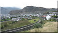
Bethania, Blaenau Ffestiniog
The residential developments line the A470 for a full mile or more away from the town centre of Blaenau Ffestiniog.
Image: © Andrew Hill
Taken: 30 Jun 2014
0.12 miles
8
Disused railway viewed from High Street, Blaenau Ffestiniog
The single track line, no longer in use, is between two low walls on the right.
Image: © Jaggery
Taken: 26 Mar 2012
0.13 miles
9
The viaduct and trackbed of former railway line at Blaenau Ffestiniog
Taken from the roadside near Bethania it shows the outline of the track which ran from Blaenau Ffestiniog to Trawsfynydd. In the background is the town of Blaenau Ffestiniog.
Image: © Richard Hoare
Taken: 7 Sep 2009
0.13 miles
10
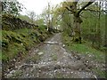
Public footpath to Manod
There is a network of paths around Blaenau Ffestiniog, linking homes, schools, quarries and chapels. This one is part of the Ardal Cwm Bowydd Area circular walk, no. 5 in the town leaflet.
Image: © Christine Johnstone
Taken: 30 Apr 2017
0.13 miles