IMAGES TAKEN NEAR TO
Bontddu, DOLGELLAU, LL40 2UB
Introduction
This page details the photographs taken nearby to LL40 2UB by members of the Geograph project.
The Geograph project started in 2005 with the aim of publishing, organising and preserving representative images for every square kilometre of Great Britain, Ireland and the Isle of Man.

There are currently over 7.5m images from over14,400 individuals and you can help contribute to the project by visiting https://www.geograph.org.uk
Image Map
Images are licensed for reuse under creativecommons.org/licenses/by-sa/2.0
Notes
- Clicking on the map will re-center to the selected point.
- The higher the marker number, the further away the image location is from the centre of the postcode.
Image Listing (31 Images Found)
Images are licensed for reuse under creativecommons.org/licenses/by-sa/2.0
Image
Details
Distance
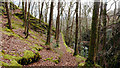
2
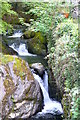
Afon Hirgwm
Rhaeadrau bach ar yr Afon Hirgwm, Bontddu / Small waterfalls on the Afon Hirgwm, Bontddu.
Image: © Ian Medcalf
Taken: 3 May 2014
0.05 miles
3
Former chapel at Bontddu
On the north side of the A496. This has been converted into a dwelling.
Image: © Eirian Evans
Taken: 10 May 2012
0.06 miles
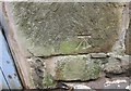
4
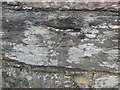
Ordnance Survey Cut Mark
This OS cut mark can be found on the SE parapet of Pont Ddu. It marks a point 9.920m above mean sea level.
Image: © Adrian Dust
Taken: 16 Oct 2022
0.07 miles
5
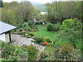
Garden at Bontddu
Tumbling down the hillside with a glimpse of the river Mawddach between the trees.
Image: © Eirian Evans
Taken: 10 May 2012
0.08 miles
6
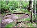
Gold mine settlement pans
As far as I remember the interpretation board said that these pans were constructed for settlement and concentration of the crushed gold ore before reacting it with mercury to form amalgam. The amalgam was then smelted to burn off the mercury and recover the gold. A leat carried water from up the hill to provide the wash water that swirled through the pans.
Image: © Neville Davey
Taken: 14 Jun 2006
0.10 miles

8
School's out!
Lollipop lady halting traffic (if there was any) outside Bontddu village school.
Image: © Eirian Evans
Taken: 10 May 2012
0.13 miles
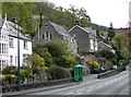
9
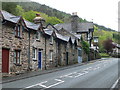
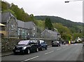
Row of terraced cottages in Bontddu
Former miners' cottages leading up to the Halfway House Inn.
Image: © Eirian Evans
Taken: 10 May 2012
0.14 miles
10
Ordnance Survey Cut Mark
This OS cut mark can be found on a building at the Halfway House Hotel. It marks a point 23.632m above mean sea level.
Image: © Adrian Dust
Taken: 10 May 2016
0.15 miles