IMAGES TAKEN NEAR TO
Bontddu, DOLGELLAU, LL40 2TT
Introduction
This page details the photographs taken nearby to LL40 2TT by members of the Geograph project.
The Geograph project started in 2005 with the aim of publishing, organising and preserving representative images for every square kilometre of Great Britain, Ireland and the Isle of Man.

There are currently over 7.5m images from over14,400 individuals and you can help contribute to the project by visiting https://www.geograph.org.uk
Image Map
Images are licensed for reuse under creativecommons.org/licenses/by-sa/2.0
Notes
- Clicking on the map will re-center to the selected point.
- The higher the marker number, the further away the image location is from the centre of the postcode.
Image Listing (15 Images Found)
Images are licensed for reuse under creativecommons.org/licenses/by-sa/2.0
Image
Details
Distance
1
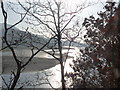
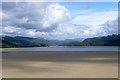
Late afternoon view down the beautiful Mawddach estuary
Image: © liz dawson
Taken: 17 Feb 2011
0.04 miles
2
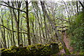
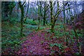
Coedgarth-Gell
Llwybr cyhoeddus mewn coedwig hynafol / Public footpath in a ancient woodland.
Image: © Ian Medcalf
Taken: 3 May 2014
0.07 miles
3
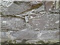
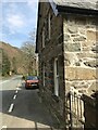
Ordnance Survey Cut Mark
This OS cut mark can be found on the roadside building at Borthwnog. It marks a point 8.524m above mean sea level.
Image: © Adrian Dust
Taken: 16 Oct 2022
0.11 miles
4
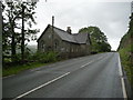
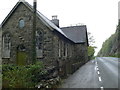
Roadside chapel and manse near the Borthwnog Hotel
Up for sale and presumably redevelopment or conversion.
Image: © Jeremy Bolwell
Taken: 1 Aug 2012
0.13 miles
5
Capel Tiberias Chapel
Between Bantddu and Pen-y-Bryn, and overlooking the Mawddach. Built in 1883 for the Independents.
Image: © Eirian Evans
Taken: 10 May 2012
0.13 miles
6
Footpath through broad leaved woodland
The RSPB has a programme of improvement of the broadleaved woodland on this site to create and better environment for birds. In my opinion that is better for walkers too.
http://google.rspb.org.uk/search?q=Coed+Garth+Gell&site=default_collection&getfields=title.type.icon.description&client=rspb2&proxystylesheet=rspb2&output=xml_no_dtd&sort=date%3AD%3AL%3Ad1&spell=1&proxyreload=0&entqr=0&ud=1&oe=UTF-8&ie=UTF-8&x=42&y=21
Image: © John Haynes
Taken: 1 Dec 2009
0.13 miles
7
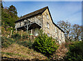
Former chapel
This former chapel near the village of Bontddu had been (2019) converted into a holiday let.
Image: © Mike Dodman
Taken: 4 Jun 2024
0.13 miles
8
View towards Pen-y-bryn
Taken from the Afon Mawddach estuary
Image: © Matthew Wilkinson
Taken: 27 Aug 2005
0.13 miles
9
Former chapel
This former chapel near the village of Bontddu had (in 2019) been converted into a holiday let.
Image: © Mike Dodman
Taken: 4 Jun 2024
0.13 miles
10
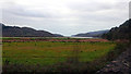
The Mawddach Estuary viewed from Borthwnog
Image: © John Lucas
Taken: 5 Jan 2019
0.14 miles