IMAGES TAKEN NEAR TO
Ganllwyd, DOLGELLAU, LL40 2TP
Introduction
This page details the photographs taken nearby to LL40 2TP by members of the Geograph project.
The Geograph project started in 2005 with the aim of publishing, organising and preserving representative images for every square kilometre of Great Britain, Ireland and the Isle of Man.

There are currently over 7.5m images from over14,400 individuals and you can help contribute to the project by visiting https://www.geograph.org.uk
Image Map
Images are licensed for reuse under creativecommons.org/licenses/by-sa/2.0
Notes
- Clicking on the map will re-center to the selected point.
- The higher the marker number, the further away the image location is from the centre of the postcode.
Image Listing (15 Images Found)
Images are licensed for reuse under creativecommons.org/licenses/by-sa/2.0
Image
Details
Distance
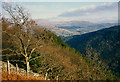
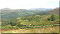
1
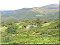
Hafod y fedw - high above the Mawddach Valley
Hafod y fedw means "the summer dwelling of the birches".
Image: © Eric Jones
Taken: 23 Aug 2007
0.03 miles
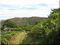
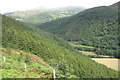
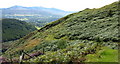
4
View north along a boggy valley
The wall in the foreground in the northernmost of the two parallel walls
Image
Image: © Eric Jones
Taken: 23 Aug 2007
0.15 miles
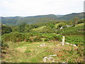
5
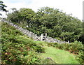
Gate and stile on path south of Hafod y fedw
Image: © Eric Jones
Taken: 23 Aug 2007
0.16 miles
6
Forestry near Hafod-y-fedw
With Rhobell Fawr in the distance.
Image: © Nigel Brown
Taken: Unknown
0.16 miles
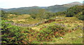
7
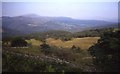
Rough grazing and forest above Hafod-y-fedw
In the distance is the large Coed y Brenin Forest.
Image: © Trevor Rickard
Taken: Unknown
0.18 miles
8
View across bracken and heather towards the hillside forest
Image: © Eric Jones
Taken: 23 Aug 2007
0.18 miles
10
Start of the walk along the precipice to Llanelltyd
Image: © Eric Jones
Taken: 23 Aug 2007
0.20 miles