IMAGES TAKEN NEAR TO
Llanelltyd, DOLGELLAU, LL40 2SU
Introduction
This page details the photographs taken nearby to LL40 2SU by members of the Geograph project.
The Geograph project started in 2005 with the aim of publishing, organising and preserving representative images for every square kilometre of Great Britain, Ireland and the Isle of Man.

There are currently over 7.5m images from over14,400 individuals and you can help contribute to the project by visiting https://www.geograph.org.uk
Image Map
Images are licensed for reuse under creativecommons.org/licenses/by-sa/2.0
Notes
- Clicking on the map will re-center to the selected point.
- The higher the marker number, the further away the image location is from the centre of the postcode.
Image Listing (34 Images Found)
Images are licensed for reuse under creativecommons.org/licenses/by-sa/2.0
Image
Details
Distance
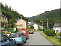
1
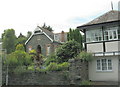
Converted school building
Some months after posting this image on Geograph, I had an interesting e-mail from a gentleman who was brought up in this house in the 1930's. The house had previously been the local schoolhouse, built in 1907. His father had named the house "Curfew" in view of the fact that the school bell had been used to toll curfew. The white building in the foreground right, somewhat remincent in outward appearance to a railway signal box, is a summer house built by the gentleman's father and "was used in the evenings as a place for the family and friends to gather for music and socialising. Beneath, at road level was garaging".
Image: © Eric Jones
Taken: 23 Aug 2007
0.07 miles
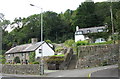
2
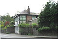
A character house alongside the A470
This house which rather reminds one of a large railway signal box is, in fact, a summer house built in the 1930s. Its upstairs rooms are certainly not short of light. The ground floor was designed as a garage.
Image
Image: © Eric Jones
Taken: 23 Aug 2007
0.09 miles
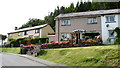
5
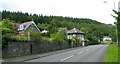
Local Authority built housing estate at Llanelltyd
Image: © Eric Jones
Taken: 23 Aug 2007
0.10 miles
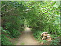
6
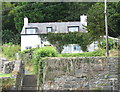
A short-cut between two roads at differing levels.
Image: © Eric Jones
Taken: 23 Aug 2007
0.10 miles
7
A garden of delights at Foelas, Llanelltyd
Image: © Eric Jones
Taken: 23 Aug 2007
0.11 miles
8
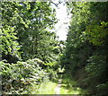
A pleasant forest path on the northern outskirts of Llanelltyd
Image: © Eric Jones
Taken: 23 Aug 2007
0.11 miles
9
Forestry road leading north from Llanelltyd village
Image: © Eric Jones
Taken: 23 Aug 2007
0.11 miles
10
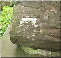
Ordnance Survey 1GL Bolt
This OS Bolt can be found on the SW angle of the church. It marks a point 21.0306m above mean sea level.
Image: © Adrian Dust
Taken: 10 May 2016
0.12 miles