IMAGES TAKEN NEAR TO
Brithdir, DOLGELLAU, LL40 2SA
Introduction
This page details the photographs taken nearby to LL40 2SA by members of the Geograph project.
The Geograph project started in 2005 with the aim of publishing, organising and preserving representative images for every square kilometre of Great Britain, Ireland and the Isle of Man.

There are currently over 7.5m images from over14,400 individuals and you can help contribute to the project by visiting https://www.geograph.org.uk
Image Map
Images are licensed for reuse under creativecommons.org/licenses/by-sa/2.0
Notes
- Clicking on the map will re-center to the selected point.
- The higher the marker number, the further away the image location is from the centre of the postcode.
Image Listing (4 Images Found)
Images are licensed for reuse under creativecommons.org/licenses/by-sa/2.0
Image
Details
Distance
1
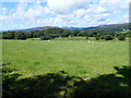
The valley of the river Wnion
View to Cadair Idris in the distance
Image: © Eirian Evans
Taken: 13 Aug 2019
0.08 miles
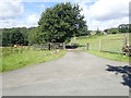
3
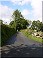
Roman Road near Brithdir
There is the remains of a roman fort in Brithdir.
http://www.roman-britain.org/places/brithdir.htm
Image: © liz dawson
Taken: 29 May 2007
0.20 miles
4
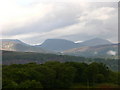
View north west towards Trawsfynydd
The beautiful Snowdonia mountains first thing in the morning.
Image: © liz dawson
Taken: 28 May 2007
0.21 miles