IMAGES TAKEN NEAR TO
Hengaer, DOLGELLAU, LL40 2RT
Introduction
This page details the photographs taken nearby to Hengaer, LL40 2RT by members of the Geograph project.
The Geograph project started in 2005 with the aim of publishing, organising and preserving representative images for every square kilometre of Great Britain, Ireland and the Isle of Man.

There are currently over 7.5m images from over14,400 individuals and you can help contribute to the project by visiting https://www.geograph.org.uk
Image Map
Images are licensed for reuse under creativecommons.org/licenses/by-sa/2.0
Notes
- Clicking on the map will re-center to the selected point.
- The higher the marker number, the further away the image location is from the centre of the postcode.
Image Listing (16 Images Found)
Images are licensed for reuse under creativecommons.org/licenses/by-sa/2.0
Image
Details
Distance
1
New housing, Brithdir
Built close to the remains of the Roman fort
Image: © liz dawson
Taken: 29 May 2007
0.01 miles
4
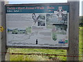
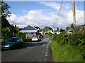
Taith Mari Jones - Mari Jones' Walk
In 1800, aged 18, Mari Jones walked barefoot from Llanfihangel y Pennant to Bala to buy a Bible, which had been translated into Welsh, from the Rev Thomas Charles. This inspired Thomas Charles to form the Bible Society in 1804. Mari would have passed through Brithdir on her 28 mile walk. Brithdir is also on the Cross Britain Way.
Image: © Eirian Evans
Taken: 13 Aug 2019
0.06 miles
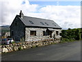
5
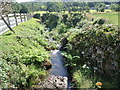
Brithdir stream
A small tributary of the river Wnion passing through Brithdir
Image: © Eirian Evans
Taken: 13 Aug 2019
0.06 miles
7
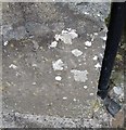
Ordnance Survey Cut Mark
This OS cut mark can be found on the SE angle of Garth View. It marks a point 159.444m above mean sea level.
Image: © Adrian Dust
Taken: 10 May 2016
0.07 miles
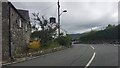
8
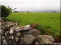
The Site Of Brithdir Roman Fortlet
This flat field is basically the internal platform of a Roman Fortlet discovered in 1961. Earthworks of the ramparts are visible,unfortunately the south-east corner is not that obvious in this photograph. Excavations show the site was occupied between AD 70 and AD 130.
Image: © Chris Andrews
Taken: 27 Sep 2016
0.07 miles