IMAGES TAKEN NEAR TO
Brithdir, DOLGELLAU, LL40 2RP
Introduction
This page details the photographs taken nearby to LL40 2RP by members of the Geograph project.
The Geograph project started in 2005 with the aim of publishing, organising and preserving representative images for every square kilometre of Great Britain, Ireland and the Isle of Man.

There are currently over 7.5m images from over14,400 individuals and you can help contribute to the project by visiting https://www.geograph.org.uk
Image Map
Images are licensed for reuse under creativecommons.org/licenses/by-sa/2.0
Notes
- Clicking on the map will re-center to the selected point.
- The higher the marker number, the further away the image location is from the centre of the postcode.
Image Listing (4 Images Found)
Images are licensed for reuse under creativecommons.org/licenses/by-sa/2.0
Image
Details
Distance
1
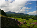
Tir amaethyddol islaw Y Foel / Farmland below Y Foel
Golygfa dros gaeau i Gadair Idris / A view across fields to Cadair Idris.
Image: © Ian Medcalf
Taken: 7 Jul 2012
0.07 miles
2
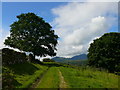
Llwybr cyhoeddus uwchben Ty'n y Cefn / Public footpath above Ty'n y Cefn
Golygfa tuag at Cadair Idris / A view towards Cadair Idris.
Image: © Ian Medcalf
Taken: 7 Jul 2012
0.12 miles
4
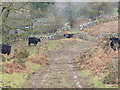
Muddy Track through a field of Welsh Black Cattle
Image: © liz dawson
Taken: 18 Feb 2011
0.19 miles