IMAGES TAKEN NEAR TO
Llanfachreth, DOLGELLAU, LL40 2PE
Introduction
This page details the photographs taken nearby to LL40 2PE by members of the Geograph project.
The Geograph project started in 2005 with the aim of publishing, organising and preserving representative images for every square kilometre of Great Britain, Ireland and the Isle of Man.

There are currently over 7.5m images from over14,400 individuals and you can help contribute to the project by visiting https://www.geograph.org.uk
Image Map
Images are licensed for reuse under creativecommons.org/licenses/by-sa/2.0
Notes
- Clicking on the map will re-center to the selected point.
- The higher the marker number, the further away the image location is from the centre of the postcode.
Image Listing (19 Images Found)
Images are licensed for reuse under creativecommons.org/licenses/by-sa/2.0
Image
Details
Distance
4

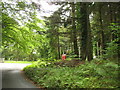
The road to Abergeirw
Beginning its climb northwards.
Image: © Nigel Brown
Taken: 26 Oct 2009
0.06 miles
5
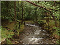
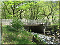
Afon Wen
Looking upstream, from the bridge at Capel Hermon.
Image: © David Medcalf
Taken: 6 Sep 2006
0.07 miles
6
Approaching the Capel Hermon T-junction from the North
Image: © Eric Jones
Taken: 31 Aug 2007
0.08 miles

8
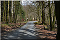
Road bridge over Afon Wen at Dolydd
The road downstream along the east side of the Afon Wen, heading for Dolgellau, is one of many narrow lanes in this part of Wales
Image: © David Purchase
Taken: 3 May 2011
0.10 miles
9
Telephone box and road junction, Capel Hermon
For a closer look at the telephone box see Image
Image: © Nigel Brown
Taken: 13 Apr 2016
0.10 miles
10
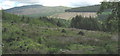
Clear fell forest in Cwm Afon Wen with Rhobell Fawr in the background
Image: © Eric Jones
Taken: 7 Jul 2007
0.11 miles