IMAGES TAKEN NEAR TO
Llanfachreth, DOLGELLAU, LL40 2NT
Introduction
This page details the photographs taken nearby to LL40 2NT by members of the Geograph project.
The Geograph project started in 2005 with the aim of publishing, organising and preserving representative images for every square kilometre of Great Britain, Ireland and the Isle of Man.

There are currently over 7.5m images from over14,400 individuals and you can help contribute to the project by visiting https://www.geograph.org.uk
Image Map
Images are licensed for reuse under creativecommons.org/licenses/by-sa/2.0
Notes
- Clicking on the map will re-center to the selected point.
- The higher the marker number, the further away the image location is from the centre of the postcode.
Image Listing (17 Images Found)
Images are licensed for reuse under creativecommons.org/licenses/by-sa/2.0
Image
Details
Distance
1
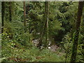
Afon Wen in the Coed y Brenin
Looking steeply down from the unclassified road which follows the course of the river.
Image: © David Medcalf
Taken: 6 Sep 2006
0.17 miles
2

Four-way road junction
In southern Coed-y-brenin.
Image: © John Lucas
Taken: 14 Feb 2019
0.18 miles
3

The Afon Wen
The river rises on the western flanks of Rhobell Fawr. It is seen here passing through mixed natural and commercial woodland not far above its confluence with the Afon Mawddach.
Image: © Nigel Brown
Taken: 26 Oct 2009
0.19 miles
4
Road junction in the forest
The layout is that of a very squashed letter 'X'. Visibility is far from good and I would not be surprised if there had been a few bumps here!
Image: © David Purchase
Taken: 3 May 2011
0.19 miles

6

The Afon Wen
Rivers in this part of Wales were pretty dry in the spring of 2011.
Image: © David Purchase
Taken: 3 May 2011
0.20 miles
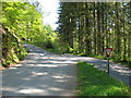
7

Road junction in the forest
A useful meeting of several minor roads which between them give access to much of the area to the east of the Afon Mawddach. The road ahead left goes to the village of Llanfachreth, that to the right eventually arrives at Dolgellau. The picture was taken from the road from east bank of the Mawddach, while the road cutting sharp back left is a through route to Abergeirw and Trawsfynydd. Before the Dolgellau bypass was built, these roads were a useful means of avoiding the Dolgellau traffic jams.
Image: © Nigel Brown
Taken: 26 Oct 2009
0.21 miles
9
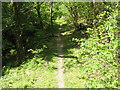
Footpath in Coed-y-Brenin forest
This path climbs gently away from the Afon Wen.
Image: © David Purchase
Taken: 3 May 2011
0.23 miles
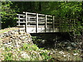
10

Minor road crossing the Afon Wen
Descending to the bridge over the river. The road is part of a route following the east bank of the Afon Mawddach.
Image: © Nigel Brown
Taken: 26 Oct 2009
0.23 miles