IMAGES TAKEN NEAR TO
Llanfachreth, DOLGELLAU, LL40 2NH
Introduction
This page details the photographs taken nearby to LL40 2NH by members of the Geograph project.
The Geograph project started in 2005 with the aim of publishing, organising and preserving representative images for every square kilometre of Great Britain, Ireland and the Isle of Man.

There are currently over 7.5m images from over14,400 individuals and you can help contribute to the project by visiting https://www.geograph.org.uk
Image Map
Images are licensed for reuse under creativecommons.org/licenses/by-sa/2.0
Notes
- Clicking on the map will re-center to the selected point.
- The higher the marker number, the further away the image location is from the centre of the postcode.
Image Listing (4 Images Found)
Images are licensed for reuse under creativecommons.org/licenses/by-sa/2.0
Image
Details
Distance
1
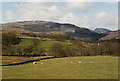
Fields near Tyddyn-b?ch farm
Taken from the Dolgellau to Llanfachreth road. Y Garn stands in the distance, with its impressive crag of Craig-y-cae clearly visible. The farm can be seen through the trees on the left.
Image: © Nigel Brown
Taken: 4 Apr 1993
0.16 miles
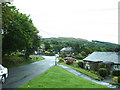
3
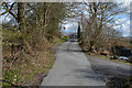
Western entry into Llanfachrech
A narrow single-track road with passing places.
Image: © Nigel Brown
Taken: 13 Apr 2016
0.22 miles
4
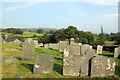
The churchyard of St.Mackreth Church, Llanfachreth
The churchyard at the southern side of the church looking east.
Image: © Jeff Buck
Taken: 18 Sep 2014
0.24 miles