IMAGES TAKEN NEAR TO
Llanfachreth, DOLGELLAU, LL40 2LW
Introduction
This page details the photographs taken nearby to LL40 2LW by members of the Geograph project.
The Geograph project started in 2005 with the aim of publishing, organising and preserving representative images for every square kilometre of Great Britain, Ireland and the Isle of Man.

There are currently over 7.5m images from over14,400 individuals and you can help contribute to the project by visiting https://www.geograph.org.uk
Image Map
Images are licensed for reuse under creativecommons.org/licenses/by-sa/2.0
Notes
- Clicking on the map will re-center to the selected point.
- The higher the marker number, the further away the image location is from the centre of the postcode.
Image Listing (12 Images Found)
Images are licensed for reuse under creativecommons.org/licenses/by-sa/2.0
Image
Details
Distance
1
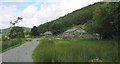
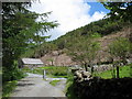
Cottages at the end of the Hafod Fraith road
The tarred road from the A470 comes to an end at the second of these cottages. The right away continues along the bridleway down to and beyond Pont Tyddyn-mawr.
Image: © Eric Jones
Taken: 7 Jul 2007
0.01 miles
2
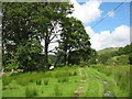
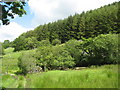
The start of the bridlepath to Pont Tyddyn-mawr
Image: © Eric Jones
Taken: 7 Jul 2007
0.09 miles
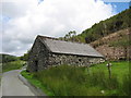
5
A cattle grid and barn beyond Hafod Fraith
Image: © Eric Jones
Taken: 7 Jul 2007
0.11 miles
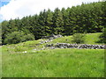
6
Overgrown ruins of a farm building alongside the Tyddyn-mawr bridlepath
Image: © Eric Jones
Taken: 7 Jul 2007
0.12 miles
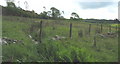
7
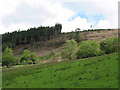
Clear fell in the Hafod Fraith private woodlands
Image: © Eric Jones
Taken: 7 Jul 2007
0.12 miles
10
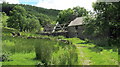
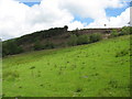
A rear view of Tyddyn-mawr
The photo also features the only two walkers that I met all day.
Image: © Eric Jones
Taken: 7 Jul 2007
0.22 miles