IMAGES TAKEN NEAR TO
Ganllwyd, DOLGELLAU, LL40 2HS
Introduction
This page details the photographs taken nearby to LL40 2HS by members of the Geograph project.
The Geograph project started in 2005 with the aim of publishing, organising and preserving representative images for every square kilometre of Great Britain, Ireland and the Isle of Man.

There are currently over 7.5m images from over14,400 individuals and you can help contribute to the project by visiting https://www.geograph.org.uk
Image Map
Images are licensed for reuse under creativecommons.org/licenses/by-sa/2.0
Notes
- Clicking on the map will re-center to the selected point.
- The higher the marker number, the further away the image location is from the centre of the postcode.
Image Listing (18 Images Found)
Images are licensed for reuse under creativecommons.org/licenses/by-sa/2.0
Image
Details
Distance
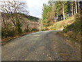
2
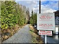
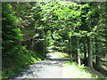
No Gold Panning
An unusual instruction on a path in Coed-y-Brenin.
Image: © Mike Parker
Taken: 2 Jan 2023
0.06 miles
3
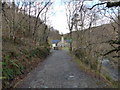
Ferndale, seen across the Afon Mawddach
Image: © David Medcalf
Taken: 29 Dec 2013
0.07 miles
5
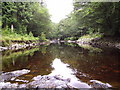
Afon Mawddach
Viewed from the 'stepping stones'
Image: © Ian in Warwickshire
Taken: 6 Aug 2005
0.08 miles
6
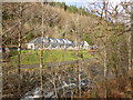
Ferndale, seen across the Afon Mawddach
Image: © David Medcalf
Taken: 29 Dec 2013
0.08 miles
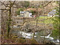
7
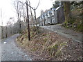
Houses above the Mawddach
These were probably connected with the once thriving mining industry in this area.
Image: © David Medcalf
Taken: 29 Dec 2013
0.09 miles
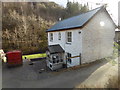
10
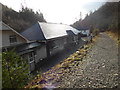
Buildings at Ferndale
These buildings were part of the stables, offices and workshops of a blasting powder works related to the local gold mines. They are now a group of holiday 'lets'.
Image: © David Medcalf
Taken: 29 Dec 2013
0.09 miles