IMAGES TAKEN NEAR TO
Llanelltyd, DOLGELLAU, LL40 2EY
Introduction
This page details the photographs taken nearby to LL40 2EY by members of the Geograph project.
The Geograph project started in 2005 with the aim of publishing, organising and preserving representative images for every square kilometre of Great Britain, Ireland and the Isle of Man.

There are currently over 7.5m images from over14,400 individuals and you can help contribute to the project by visiting https://www.geograph.org.uk
Image Map
Images are licensed for reuse under creativecommons.org/licenses/by-sa/2.0
Notes
- Clicking on the map will re-center to the selected point.
- The higher the marker number, the further away the image location is from the centre of the postcode.
Image Listing (8 Images Found)
Images are licensed for reuse under creativecommons.org/licenses/by-sa/2.0
Image
Details
Distance
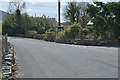
3
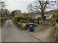
Pandy-bach
Pandy-bach means "little fulling mill".
Image: © Eric Jones
Taken: 18 Jul 2007
0.11 miles
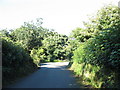
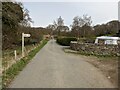
4
View east along minor road south of Nannau Hall
Image: © Eric Jones
Taken: 18 Jul 2007
0.14 miles
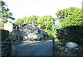
7
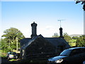
A Nannau estate cottage with its distinctive chimneys
The telephone box at the junction can be seen to the left of the cottage.
Image
Image: © Eric Jones
Taken: 18 Jul 2007
0.24 miles
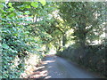
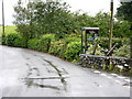
8
Telephone box by road junction
Partly recessed into the garden of the cottage by the junction.
Image: © Nigel Brown
Taken: 13 Apr 2016
0.24 miles