IMAGES TAKEN NEAR TO
Pencefn Road, DOLGELLAU, LL40 2ET
Introduction
This page details the photographs taken nearby to Pencefn Road, LL40 2ET by members of the Geograph project.
The Geograph project started in 2005 with the aim of publishing, organising and preserving representative images for every square kilometre of Great Britain, Ireland and the Isle of Man.

There are currently over 7.5m images from over14,400 individuals and you can help contribute to the project by visiting https://www.geograph.org.uk
Image Map
Images are licensed for reuse under creativecommons.org/licenses/by-sa/2.0
Notes
- Clicking on the map will re-center to the selected point.
- The higher the marker number, the further away the image location is from the centre of the postcode.
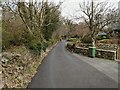
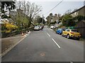
Image Listing (6 Images Found)
Images are licensed for reuse under creativecommons.org/licenses/by-sa/2.0
Image
Details
Distance
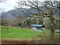
1
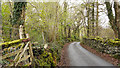
Minor road north of Dolgellau
The road is part of the National Cycle Network; route No. 8.
Image: © Trevor Littlewood
Taken: 18 Apr 2012
0.03 miles
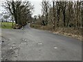
6
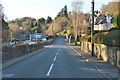
The old A470 heading west from Dolgellau
At one time carrying all major traffic heading north and through Barmouth.
Image: © Nigel Brown
Taken: 20 Jan 2017
0.25 miles