IMAGES TAKEN NEAR TO
Llanfachreth, DOLGELLAU, LL40 2DY
Introduction
This page details the photographs taken nearby to LL40 2DY by members of the Geograph project.
The Geograph project started in 2005 with the aim of publishing, organising and preserving representative images for every square kilometre of Great Britain, Ireland and the Isle of Man.

There are currently over 7.5m images from over14,400 individuals and you can help contribute to the project by visiting https://www.geograph.org.uk
Image Map
Images are licensed for reuse under creativecommons.org/licenses/by-sa/2.0
Notes
- Clicking on the map will re-center to the selected point.
- The higher the marker number, the further away the image location is from the centre of the postcode.
Image Listing (24 Images Found)
Images are licensed for reuse under creativecommons.org/licenses/by-sa/2.0
Image
Details
Distance
1
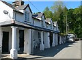
Cottages at Llanfachreth
Cottages with colonnade between the church and the school at Llanfachreth. Between the centre two windows there is a small plaque dated 1812 with the letters V RW.AM above.
Image: © Eirian Evans
Taken: 10 Jun 2013
0.01 miles
3
Llanfachreth School
Built, under the instructions of Robert Wms Vaughan, in 1847. Many children had to walk great distances through the parish and, as the log for 31 August 1887 attests, would miss lessons for other reasons... "Only 26 scolars present this morning, the weather being most favourable for the farmers to get their hay in, which was fast spoiling owing to the constant bad weather we have had of late". It closed in 2015.
Image: © Eirian Evans
Taken: 10 Jun 2013
0.03 miles
4
Llanfachreth School
Llanfachreth school was built in 1847 and now teaches children between the ages of 3 and 11.
Image: © Jeff Buck
Taken: 18 Sep 2014
0.04 miles
5
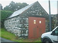
Ty Hers
Set against the churchyard wall is this 11kV electricity substation where in time past the hearse was kept. The plate on the door has the legend 'Ty Hers 10 7522 013'. 10 represents the district according to the old MANWEB designation, 7522 tells you that you are in that grid square and 013 is the substation number.
Image: © Ed Lloyd-Hughes
Taken: 8 Jun 2011
0.04 miles
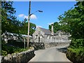
6
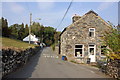
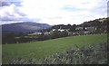
Llanfachreth
The building on the right was once the village shop, now a private residence.
Image: © Jeff Buck
Taken: 18 Sep 2014
0.04 miles
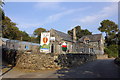
8
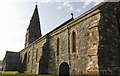
St. Machreth Church, Llanfachreth
Dedicated to Celtic Saint Machreth, the present church at Llanfachreth has been extensively restored over the centuries. It is now a Grade II listed building.
Image: © Jeff Buck
Taken: 18 Sep 2014
0.05 miles
10
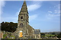
St. Machreth Church, Llanfachreth
Dedicated to Celtic Saint Machreth, the present church at Llanfachreth has been extensively restored over the centuries. It is now a Grade II listed building.
Image: © Jeff Buck
Taken: 18 Sep 2014
0.06 miles