IMAGES TAKEN NEAR TO
Llanfachreth, DOLGELLAU, LL40 2DL
Introduction
This page details the photographs taken nearby to LL40 2DL by members of the Geograph project.
The Geograph project started in 2005 with the aim of publishing, organising and preserving representative images for every square kilometre of Great Britain, Ireland and the Isle of Man.

There are currently over 7.5m images from over14,400 individuals and you can help contribute to the project by visiting https://www.geograph.org.uk
Image Map
Images are licensed for reuse under creativecommons.org/licenses/by-sa/2.0
Notes
- Clicking on the map will re-center to the selected point.
- The higher the marker number, the further away the image location is from the centre of the postcode.
Image Listing (9 Images Found)
Images are licensed for reuse under creativecommons.org/licenses/by-sa/2.0
Image
Details
Distance
1
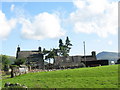
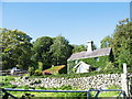
Ffermdy Rhedyn Cochion (Ffrainc) Farmhouse
This farm has two names - Rhedyn Cochion meaning "red bracken" and Ffrainc meaning "France".
Image: © Eric Jones
Taken: 18 Jul 2007
0.01 miles
3
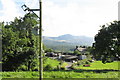
Rhedyn-cochion farmhouse framed against Cadair Idris mountain
Image: © Eric Jones
Taken: 18 Jul 2007
0.02 miles
4
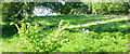
Attempting to control the bracken menace at Cae Gwyn by spraying Asulox herbicide
Image: © Eric Jones
Taken: 18 Jul 2007
0.07 miles
6
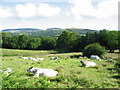
A Charolais bull and his harem at Rhedyn-cochion
Image: © Eric Jones
Taken: 18 Jul 2007
0.09 miles
7
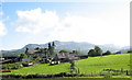
Cae Gwyn - built in the distinctive Nannau Estate style
Image: © Eric Jones
Taken: 18 Jul 2007
0.09 miles
8
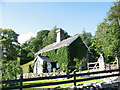
Ivy-clad Cae Gwyn cottage
Cae Gwyn simply means "white field".
Image: © Eric Jones
Taken: 18 Jul 2007
0.10 miles