IMAGES TAKEN NEAR TO
Rhydymain, DOLGELLAU, LL40 2BH
Introduction
This page details the photographs taken nearby to LL40 2BH by members of the Geograph project.
The Geograph project started in 2005 with the aim of publishing, organising and preserving representative images for every square kilometre of Great Britain, Ireland and the Isle of Man.

There are currently over 7.5m images from over14,400 individuals and you can help contribute to the project by visiting https://www.geograph.org.uk
Image Map
Images are licensed for reuse under creativecommons.org/licenses/by-sa/2.0
Notes
- Clicking on the map will re-center to the selected point.
- The higher the marker number, the further away the image location is from the centre of the postcode.
Image Listing (10 Images Found)
Images are licensed for reuse under creativecommons.org/licenses/by-sa/2.0
Image
Details
Distance
1
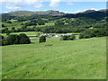
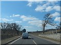
Esgair Gawr
Livestock and poultry farm east of Rhydymain
Image: © Eirian Evans
Taken: 13 Aug 2019
0.01 miles
4
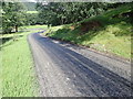
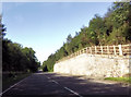
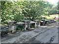
Newly surfaced road
Section of a minor road between Bryn-Coed-Ifor and Drws-y-Nant.
Image: © Eirian Evans
Taken: 13 Aug 2019
0.18 miles
6
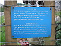
Mosquito memorial plaque.
For a photo of the actual engine see Image
Image: © Hefin Richards
Taken: 3 Jun 2007
0.23 miles
8
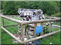
Memorial to Mosquito crash.
To see the plaque detail see Image
Image: © Hefin Richards
Taken: 3 Jun 2007
0.24 miles
9
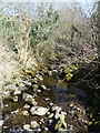
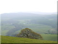
Ceunant Coch
From the bridge under the farm at Esgair gawr
Image: © Michael Graham
Taken: 29 Mar 2012
0.24 miles
10
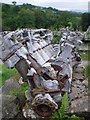
Mosquito engine memorial.
Image: © Hefin Richards
Taken: 3 Jun 2007
0.24 miles